In Algonquin Provincial Park, I wander past a beaver pond, of which there are thousands in the park. Characteristically gnawed stumps dot the edge of the woodlands, but no beavers (Castor Canadensis) in sight. With their formidable teeth, beavers can chew through a tree—a minute or two for branches, maybe half a day for a 12-inch diameter tree. The aspen and willows that once provided forest shade for a trickling stream have been felled by the beaver, not only for food—they bite off the outer bark to get to the thin layer beneath with its high sugar content—but also to build a dam.
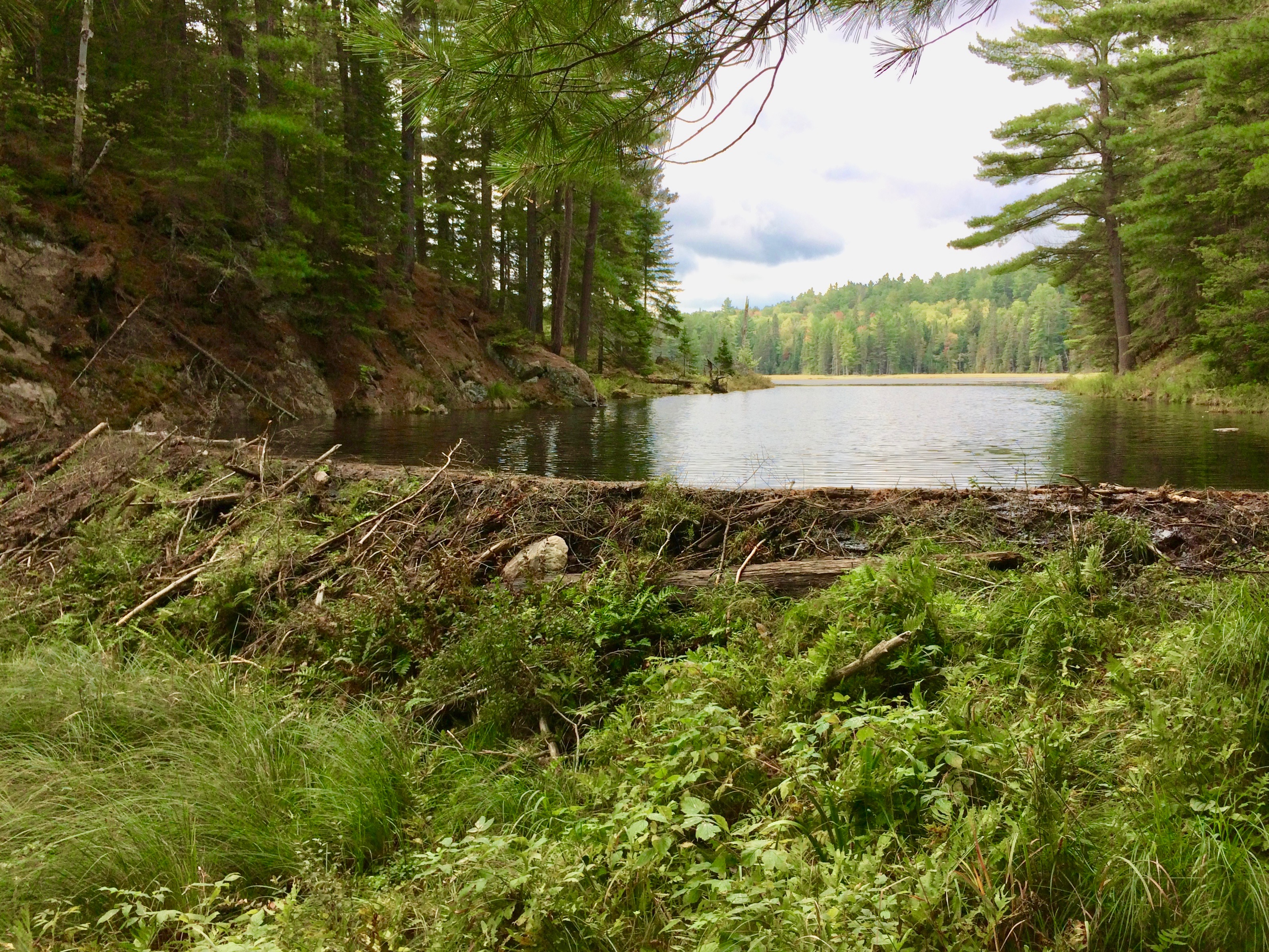
The dam holding back this particular beaver pond is an engineering marvel, spanning the narrow ravine that opens into the broad pond. Humans would be hard pressed to build a dam with just sticks and mud that holds back a two- or three-acre pond with only a little water dribbling through.

Moose (Alces alces) come to the pond to browse on lilies and waterweed, lifting their massive heads dripping with water and a mouthful of aquatic plants ripped from the bottom with their prehensile upper lip. Ducks settle on the pond’s surface, while dragonflies flit from plant to plant. Herons stalk the shallows for frogs and fish. Turtles bask on fallen logs. The deeper water of the pond provides protection for species that would not find the original stream habitat suitable. Otter (Lontra canadensis) flow through the water or frolic on shore. Mink (Neovison vison), also a member of the mustelid, or weasel, family and also semi-aquatic, frequent the beaver ecosystem.

Now, who thinks of the lowly beaver as a keystone species? Normally, we think of an apex predator—bear, wolf, cougar. But the beaver creates and maintains an aquatic ecosystem that supports everything from fish and frogs to moose. In times of drought, beaver ponds hold water on the landscape with their deeper pools and less surface area for evaporation per cubic feet of water, while also recharging the groundwater. In this new world of climate change that all species will face, beaver ponds may represent salvation in the warm, dry months of a future summer.
The oldest provincial park in Canada, established in 1893, and named to commemorate the aboriginal people of the region, Algonquin Provincial Park protects nearly 3,000 sq. mi. (7,800 sq. km.) of the converging northern coniferous forest and southern deciduous forest, providing a myriad of habitats with its 2,400 lakes and hundreds of miles of streams and rivers. Diverse habitat supports diverse species—in Algonquin, 50 or more mammals, nearly 300 bird species, 30 reptiles and amphibians, 54 species of fish, and thousands of insects and plants.
This is an important stronghold for species, as is evident in the considered opinion that Algonquin is the likely birthplace of the eastern coyote (Canis latrans “var.”), or “Coywolf” as its called, a hybrid of the eastern wolf (Canis lycaon) and the western coyote (Canis latrans).

The coywolves spread east as far as Nova Scotia, crossing Cabot Strait to Newfoundland Island, and south through New York, perhaps as far south as Virginia. Reclusive and adaptive like their coyote ancestors, they easily move through human-occupied landscape and were certainly among the first to use the modern-day “A2A” Corridor linking Algonquin to Adirondacks.
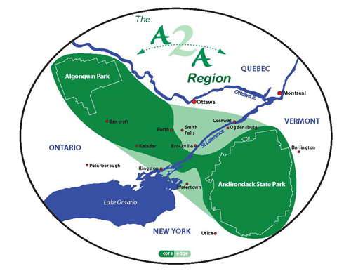
The vision for linking the two parks, Algonquin in Ontario south to Adirondack Park in New York, originated in the early 1990s, but it was not until 2000 that a formal A2A Conservation Association, as it was originally called, was formed. The A2A region covers an area of 93,000 sq. km, a little larger than the province of New Brunswick and about the size of the state of Maine.
Greater tree cover and fewer roads along this stretch of North America provide opportunity for wildlife migration and create a critical link for connectivity, and therefore biodiversity and ecological integrity, between the boreal forests of the North with the Appalachian Mountain range to the south and east of the Adirondack Mountains. Indeed, the A2A corridor forms the obvious link between two wildways designated by the Wildlands Network™—the Eastern Wildway© just to the east of the Adirondacks and the Arctic/Boreal Wildway© to the north of Algonquin Park.
The Algonquin to Adirondacks Collaborative, as it’s known now and headquartered in Lansdowne, Ontario, just north of the Canadian-U.S. border, oversees efforts to establish and maintain the A2A corridor. A multi-national collaborative, with a network of partners in both countries plus First Nations, the Collaborative works to protect and restore natural habitat, although not in an uninterrupted preserve. Rather, the plan is to connect parks and reserves by working with landowners to leave over-grown fence lines, woodlands, tree cover along stream banks, wetlands, all of which are natural migration routes through the human habitat between the two large parks and smaller protected areas within the corridor. Part of the task is to promote land stewardship with the goal of sustainable use in those areas not protected, while maintaining the traditional rural economy of the region.
David Miller serves as Executive Director for the A2A Collaborative. But when I first explored the A2A Corridor, Lilith Wyatt was Coordinator for the Collaborative. “There’s a very distinct Precambrian shield from the boreal forest down to the Adirondacks,” Wyatt said. The A2A corridor lies on the southern end of the Canadian Shield, the largest exposed region of undisturbed North American continental crust and some of the oldest rock on earth. Its mountains, now eroded to hills, formed a region of North America thought to be the first area to permanently rise above sea level. Composed mostly of igneous rock scarred by glaciers, the Canadian Shield is a land of thin soil, granite outcrops, eroded ridges supporting a forest of fir, pine, and spruce interspersed with temperate deciduous species, and valleys brimming with wetlands and lakes.

The exposed shield to the north is U-shaped, hugging the shores of Hudson Bay. To the south, the shield stretches into the U.S. as the Superior Upland around the Great Lakes and southeast into New York to include the dome of the Adirondacks. However, the shield narrows where it crosses into New York in a virtual bridge, called the “Frontenac Arch,” or sometimes “Axis.”
The Frontenac Arch remains relatively unimpacted by human activity, mostly because of relatively thin soil. When deciding upon a place to establish colonies, French settlers and later the British favored the sedimentary St. Lawrence Lowlands to the northeast and the Great Lakes Lowlands to the southwest that flank the Arch. Modern towns follow the same pattern, with the Arch standing between Brockville to the northeast and Kingston to the southwest.
Similar topography, soil, and forest communities along the Frontenac Arch draw plants and animals north and south, naturally creating a corridor. As the critical link in the A2A, the Frontenac Arch provides an exceptional chance to preserve a migration corridor for eastern North American wildlife. As Cathy Keddy explains in The Conservation Potential of the Frontenac Axis: Linking Algonquin Park to the Adirondacks:
… southern species extend their distribution north along the Axis, northern species extend their distributions south along the Axis, widespread species concentrate on the Axis, forest-dependent species use the Axis as a migration route and breeding habitat, and the high diversity of environmental conditions, in turn, supports high species diversity and numerous rare species.
Recognizing the global significance of the Frontenac Arch region, the United Nations Educational, Scientific and Cultural Organization (UNESCO) designated the Arch a World Biosphere Reserve in 2002. To support the Frontenac Arch Biosphere, or “FAB” as it’s locally called, volunteers and representatives of governments and organizations have formed a network to encourage sustainable living that encompasses conservation of the region’s ecology.
Sara Matheson, who at the time was Executive Director of the FAB Network and shared offices with the A2A Collaborative in a small stone building in Lansdowne, says, “We’ve been at it almost 15 years, which may seem like a long time, but you know, with a grassroots effort it takes a long time.” Her comment echoes the view of Wallace Stegner in his essay, It All Began with Conservation, “Environmentalism or conservation or preservation, or whatever it should be called, is not a fact, and never has been. It is a job.”

Matheson described the narrowing of the A2A corridor in the Frontenac Arch as a “choke point for wildlife migration because the habitat is different where it drops off to either side, northeast and southwest. The habitat is predominantly pitch pine and granite outcrops with many lakes.” And in fact, I see on a map that the Canadian Shield has an hourglass shape where it extends into the U.S. and has a more significant number of lakes and ponds than the sedimentary lands to either side.
The A2A Collaborative office has since moved to the old municipal building in Lansdowne, while the FAB Network office has moved to the community center with Julie Servant as Executive Director.
Biosphere Reserve is not the only UNESCO designation for the region; in addition, the Rideau Canal has been a World Heritage Site since 2007 in recognition of its historical significance and engineering. While the Rideau Canal cutting across the A2A corridor changed the habitat somewhat, the impact of canal construction is probably miniscule compared to the current major transportation route east-west across the Frontenac Arch. A four-lane thoroughfare, Highway 401 presents a formidable obstacle for wildlife moving north-south, especially in sections where oncoming traffic is separated by concrete barriers. Wyatt confirmed, “Roads are a problem because of the deterrent—some animals simply turn back when encountering the heavy traffic on 401—but also because of mortality.” ( See sidebar “Road Ecology.”)
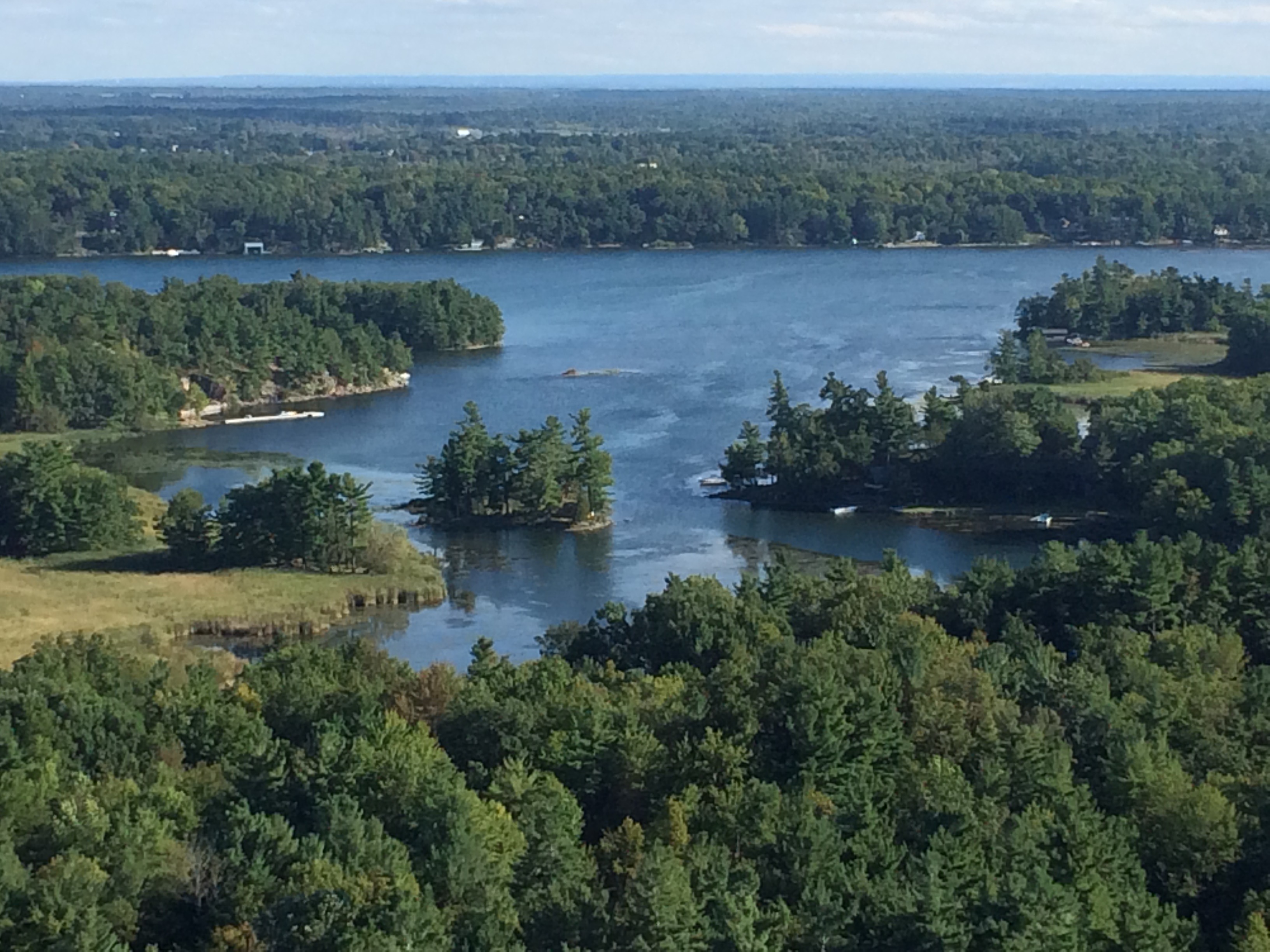
That brings us to the final major obstacle, the St. Lawrence River. And once again, the Frontenac Arch proves to be the vital link in the A2A corridor, creating a multitude of stepping-stone islands that assists wildlife in crossing the river.
During the last ice age, glaciers gouged out the Great Lakes basins, which then filled with rain and runoff from surrounding watersheds as well as melt water from receding glaciers. Once the ice fully retreated, the area was below sea level, having been compressed by the weight of the ice, and so for a time became a bay of the Atlantic Ocean. However, released from the weight of ice, the land rebounded, and as the water receded, the granite peaks and knobs of the Frontenac Arch thrust above the water’s surface leaving more than 1,000 islands stranded at the outlet of Lake Ontario. From here, the waters swept down the St. Lawrence River, which became the primary outflow of the Great Lakes to the ocean.
Crossing from Canada into the U.S., I’m lifted high over the St. Lawrence on the Thousand Islands Bridge, actually a system of five bridges with the largest span a grand sweep towering above the river. “Thousand Island Bridge,” says John Keats—not the Romantic poet, but rather a 20thcentury journalist and author—“connects the two nations by leaps of imagination.”

In Keats’ autobiographical Of Time and an Island, “JK” as he was called recounts the years his family lived on two-acre Pine Island in a house “less substantial” and where he wrote in a small cabin at the head of the island. Reading the book today evokes a timelessness mid-century before the islands became crowded with vacationers in summer and when many locals still lived on islands amid the more palatial homes of the wealthy. Many could say with Keats, “We live in a house on a stone in the middle of a river in the center of the world at the very heart of time.”
The Keats and their friends spent the warm months fishing, swimming, visiting each other by boat. “At any season islands keep a different time from mainlands,” he says, “but on an island in high summer there is only summertime.” Returning to their island after spending winters elsewhere,
…first we would go out onto the porch that was cantilevered over the water and look down the passages of the great river and know why we had come. We were home and felt as if we had never been away.
The early 19thcentury English Romantic poet, John Keats, would have understood JK’s emotion when returning to Pine Island:
To one who has been long in city pent,
‘Tis very sweet to look into the fair
And open face of heaven, —to breathe a prayer
Full in the smile of the blue firmament.
In today’s Thousands Islands region, there are yet enough smaller, uninhabited islands as well as forest stands on larger, inhabited islands that provide opportunity for migrating species along the A2A corridor to make the river crossing.

In a 50-mile stretch of the St. Lawrence where it flows from Lake Ontario and passes over the Frontenac Arch, more than 1800 islands are scattered like handfuls of thrown dice, ranging in size from 40 square miles to a mere outcrop of granite with a lone tree marking its presence. Moose, deer, probably bear, “timber wolves” (coyotes and coywolves), and many smaller mammals swim from island to island across the river expanse. Most winters, the river freezes so that the animals can simply walk across. On Pine Island, Keats recounts, “Deer will come tiptoeing across the frozen river and pause among our trees.”
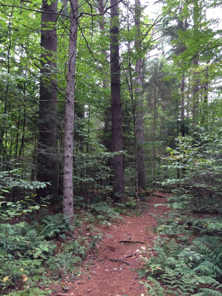
Once they have made their way across the St. Lawrence, mammals heading south then have a straight run for the Adirondacks of about 30 miles. Certainly they must cross highways and navigate through human settlements. But lakes, river corridors, and scattered pockets of protected areas ease their way, and greater tree cover than in other regions of New York State provide semi-natural habitat fragments.
At 6.1 million acres, Adirondack Park is the largest park east of the Mississippi River and, although a state park, one of the largest in North America—almost three times the size of Yellowstone National Park. However, as an unusual amalgam of public and private lands within its boundaries, the park has less than half of the area preserved in the state-owned Adirondack Forest Preserve (2.7 million acres). The remainder is occupied by towns, hamlets, and individually owned parcels.
Moose began returning to the region in the 1980s from Vermont and New Hampshire, some “tiptoeing” across the ice on Lake Champlain and Lake George. Around 400 are reported to now live in the park, down from earlier promising estimates ranging from 600 to 1,000. Across the southern part of their range, moose are in decline because of warming temperatures from climate change and the inevitable increase in disease and pests that thrive in the heat. However, Adirondack moose, although also in decline, are reported to be bigger and healthier than other moose populations from Minnesota to Maine and New Brunswick.
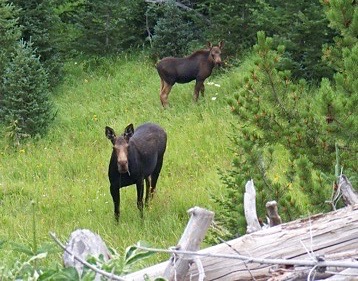
Adirondack moose (Alces alces) are known to sometimes migrate north. Providing inspiration to the A2A effort, a 700-pound moose—“Alice,” a female (“cow”) collared in the Adirondacks—left the park headed north in 2000. Crossing the St. Lawrence River and stepping across the four lanes of Highway 401, Alice later arrived in Algonquin Provincial Park the following year, covering about 400 miles. Alice died of unknown cause at Algonquin. Alice’s travels provided clear proof that the A2A corridor still exists, despite the obstacles wildlife encounter.
To commemorate the journey of Alice the Moose, the A2A is working with its partners on a proposed trail linking the Adirondacks with Algonquin, taking advantage of existing trails and in the interim designating road connections until new trail can be constructed. On October 1, 2017, John Allport departed Algonquin headed south while John Davis left the Adirondacks headed north, tracing a possible route for the A2A Trail. The two met on Wellesley Island in the St. Lawrence River with other hikers and supporters to link the two halves and celebrate their journey. In 2019, the route consists of 193 miles of hiking trail, 56 miles of rail trail, and 210 miles along roads, with the long-term goal of providing alternatives to at least the major roadways of about 95 miles so those sections may be more easily walked or biked. John Davis, one of the founders of the Wildlands Network™, had earlier completed Trek East. In 2011, he started in Florida and hiked, canoed, bicycled the general route of the Eastern Wildway© proposed by the Network. He concluded, “an Eastern Wildway is still possible, but only with a degree of cooperation for the greater good such as we’ve seldom seen before.”
© Russ Manning. All Rights Reserved.
An ebook copy of much longer text and complete references for Algonquin to Adirondacks can be downloaded from amazon.com

