We check the guidebook again. The map still shows the trail leading along the Kayenta Bench and traversing the Great Alcove. This huge depression in the canyon’s side appears to be a seamless rock wall, and we wonder how we are to get across that sheer face of stone. Like a herd of horses refusing to plunge into the river, we mill around the edge, reluctant to believe that’s the way to go.
I’ve joined a group of desert ramblers led by Roger Jenkins, at the time with the Tennessee Sierra Club Harvey Broome Group. This trip, to hike the Dirty Devil River Canyon in southern Utah between Capitol Reef National Park on the west and Glen Canyon National Recreation Area on the east. The Dirty Devil runs southeast and south through lands managed by the Bureau of Land Management (BLM) before the river enters Glen Canyon NRA and joins the Colorado River.
Roger has been organizing these annual desert canyon trips for several years. I’ve been with the group twice before, backpacking the Escalante and Paria River Canyons. Although those trips were a stroll down the canyon with several river crossings, this time we learn the descent into the canyon might be a bit tricky. A “little exposure and some talus slope” is the way Roger put it. In addition to Roger and me are George Ritter, Will Skelton, Samantha Richter, Kevin Pack, Andy Zenick, John Finger, Ray Payne, Andy Butler, and Sue Fischer. Roger and wife, Suzy, now live in Bozeman, and we occasionally hook up when I’m in Montana.
From Hanksville, Utah, we head southeast on UT 95, according to the map paralleling the Dirty Devil River to the east. The seemingly flat, wind-swept surface of the Colorado Plateau shows no evidence of the distant defile that harbors the river’s course, cut into the plateau by flash floods and the endlessly flowing stream, if at times only a trickle.
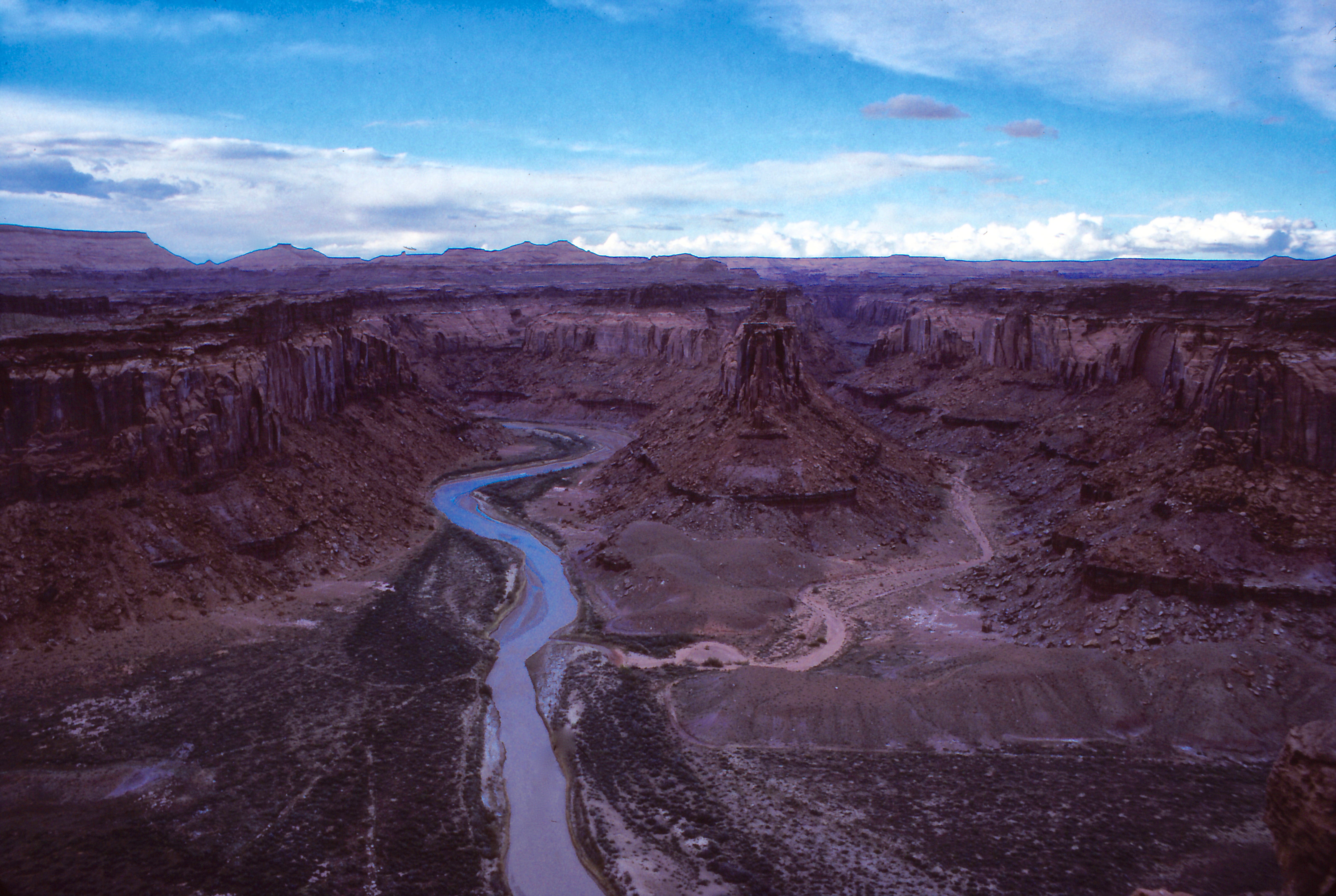
We soon turn onto an unpaved road that leads to Angel Point. The vehicles, a car and a van, bump over the dirt road and fishtail in patches of loose sand. At the point, the Dirty Devil shows itself for the first time, a muddy, serpentine stream slithering its way in a deep gorge that reminds us of the inner Grand Canyon.
The river’s name originated with John Wesley Powell’s famed exploration of the Colorado River and its canyons in 1869. On July 28th, as the exploration party floated down the Colorado River,
… we discover the mouth of a stream which enters from the right. Into this our little boat is turned. The water is exceedingly muddy and has an unpleasant odor. One of the men in the boat following, seeing what we have done, shouts to Dunn and asks whether it is a trout stream. Dunn replies, much disgusted, that it is “a dirty devil,” and by this name the river is to be known hereafter.
Powell and his party must have come by after a recent storm had washed the river canyon, muddying the water. Although the disgust might have been justified. Edward Abbey in his elegy to the American Southwest, Desert Solitaire, recounts that a prospector searching for uranium ore reported a poison spring at the source of the Dirty Devil “a few years ago”—the book was first published in 1968.
We leave the car to serve as a shuttle at the end of the backpack, crowd into the van, and drive back to the highway, down several miles, and then onto another dirt road that leads through the Burr Desert to Burr Point. The road eventually ends at the edge of the canyon. We unload in a desolate landscape—sand, sagebrush, the wind ripping unimpeded across the flat desert—the Henry Mountains behind us, the canyon of the Dirty Devil before us. I look down perhaps a thousand feet to the river. It’s early afternoon with clouds gathering, and somehow between now and end of the day, the group must get from here to there. I begin to wonder if I’m about to be swept into the abyss of adventure. But then, that’s why I am here. We shrug into packs and head out.
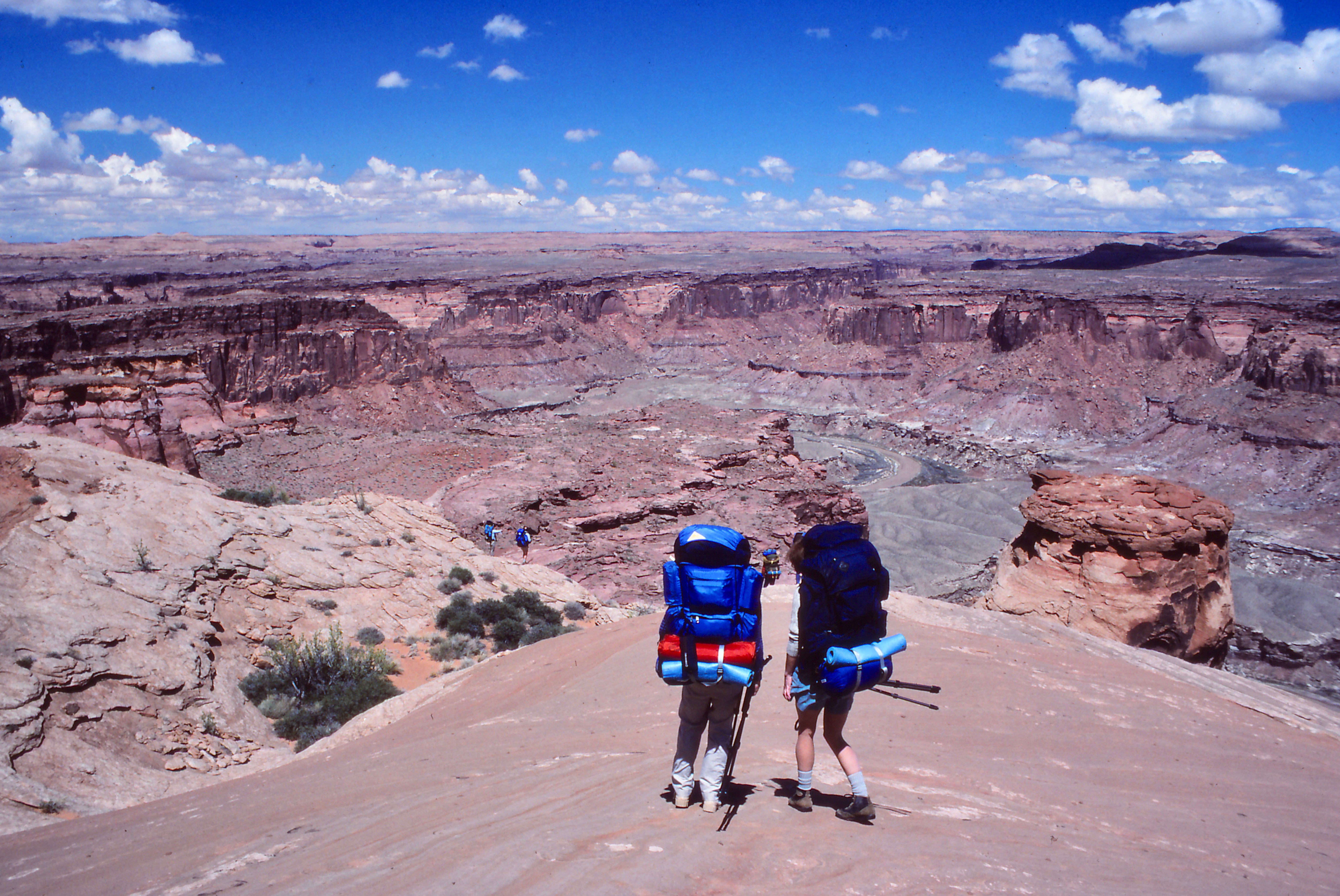
As we begin our descent from Burr Point, the initial sandy slope is stable, like walking on a sand dune. A few cairns mark the way. We then pick our way down steep rock slopes, dropping from benches that are different erosional levels in the canyon wall—the Carmel and Navajo formations. The descent is made more difficult with the 50-to-60 pound packs that carry a week’s gear and provisions.
Arriving at the top of a rock cliff in the Navajo formation that drops to the Kayenta Bench, Ray and George set up a line to lower packs by rope. George has already climbed down to untie each pack at the bottom. With the packs lowered, we make a single-file, zigzagging descent of the rock shelf.

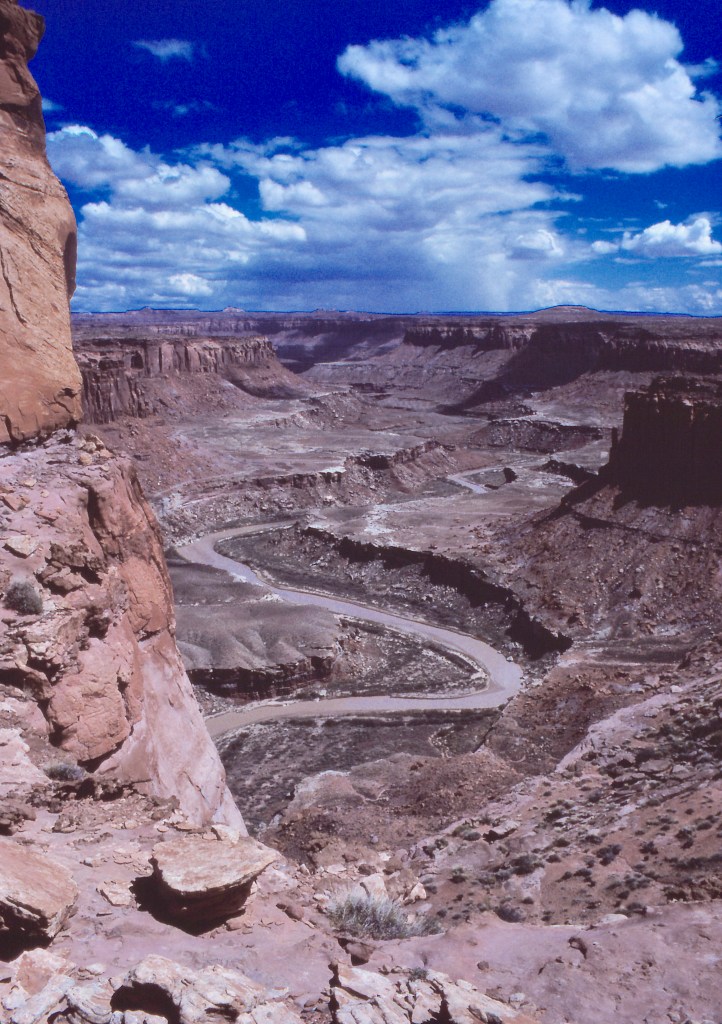
Once on the Kayenta Bench, we have some level walking and cross a saddle separating twin buttes from the canyon wall. But abruptly we arrive at the edge of a sheer drop into a side gorge. Michael Kelsey’s map in Hiking and Exploring Utah’s Henry Mountains and Robbers Roost indicates we’re to stay along the canyon wall, walking along the bench until we cross the Great Alcove that can be seen on the other side of this notch in the canyon. All we see of the Great Alcove across the expanse is blank wall, a wound in the side of the canyon where rock has fallen away. How can anyone walk across that? Our mutual indecisiveness is voiced in cries of “It can’t be done,” “Mike Kelsey is crazy.” But Mike has been exploring and writing guidebooks on the Colorado Plateau since the 1980s and we’ve trusted his judgment before. While we discuss whether we should again, Ray, in his no nonsense way, has dropped his pack and headed off to scout the trail. Perhaps the strongest hiker in the group, and with a reputation for surefootedness, Ray will find the way if there is one.
But many of us doubt even Ray’s ability to get across the Great Alcove. A few of us suggest hiking back out the way we came and taking an alternative route. But after a time, we grow silent and wait to see what Ray finds. After about twenty minutes of circumnavigating this side gulf, he’s almost there, only a speck now across the divide. We wait as if for the Rapture.
Ray then steps out, sauntering nonchalantly as if on a highway. There must be a shelf, because there is Ray on a Saturday afternoon stroll. The distance has made the wall appear two-dimensional to us on this side of the canyon. “Well, if we are going to do it,” Sue says, “we’d better start so we can get to the bottom before dark.” Ray turns and heads back to get his pack.
The rest of us hoist packs and set off. I am still a bit dubious. We walk on a 30-degree slope of loose sand and rock that to my right slips over a several hundred-foot drop into the canyon. Looking where I’m stepping, I know I cannot fall. Looking out over the canyon, vertigo threatens; so I turn my cap and pull down the brim to block the view.
J.W. Powell noticed a similar phenomenon when exploring a rock face along the Colorado River corridor:
It is curious how a little obstacle becomes a great obstruction when a misstep would land a man in the bottom of a deep chasm. Climbing the face of a cliff, a man will without hesitancy walk along a step or shelf but a few inches wide if the landing is but ten feet below, but if the foot of the cliff is a thousand feet down he will prefer to crawl along the shelf.
In and out on the undulating wall, we hike on the same level, not needing to descend or ascend. This is still the Kayenta Bench, but it has narrowed to just a few feet wide around the head of the defile.
Finally rounding the bend, we reach the Great Alcove. Incredibly, a ledge stretches across the face of the wall. Maybe not a highway, but certainly a sidewalk; easy. As usual the anticipation was worse that the act itself. It’s like sex, according to Ed Abbey when describing a run through a big river rapid in his essay, “A Colorado River Journal” in Beyond the Wall, Essays from the Outside. “… half the fun lies in the anticipation. Two-thirds of the thrill comes with the approach. The remainder is only ecstasy—or darkness.”
We quickly cross the shelf, scramble up, and continue along the Kayenta Bench, which opens into a broad shelf. I pick up speed, able to hike with strength on the open ground.
Approaching the canyon edge again, we follow it to the back end of another notch topped by the Twin Alcoves, which according to Kelsey’s map marks our final descent to the canyon bottom. Large boulders have fallen over the eons as the alcoves were formed, piling up against the canyon wall. This actually enables the descent of the otherwise sheer wall of the Wyngate Sandstone layer. Slowly, the group works its way down from rock to rock. I’m starting to get tired and wonder if my legs will continue to support me as I step down with the heavy pack added to my weight. The rubble zone goes on and on, past the Chinle layer where uranium deposits are typically found, the Shinarump Conglomerate, the Moenkopi Formation, the Kibab Limestone. To save my legs, I sometimes slide on my rear and, when the rocks are big, use both hands, working down the slope. I scrape knees and hands, and I’m reminded of Ed Abbey’s admonition in Desert Solitaire to not try to see from a car the place he unabashedly calls “the most beautiful place on earth.”
In the first place you can’t see anything from a car; you’ve got to get out of the goddamned contraption and walk, better yet crawl, on hands and knees, over the sandstone and through the thornbush and cactus. When traces of blood begin to mark your trail you’ll see something, maybe.
Finally we bunch up where the group must descend a minor cliff in the White Rim Sandstone that is the final geologic level before reaching the canyon bottom. The next in line waits for the one ahead to clear before making the descent. Will, the most experienced climber, sits on a rock halfway in the descent. He talks everyone down, offering advice on where to place hands and feet. I’m at the rear, but Andy offers to let me go next. I accept—something reassuring about having someone behind you. I do the first part of the cliff well. I scoot down a shelf and traverse around a bush. With Will directing, I then back down the cliff with a few footholds.
One last smooth vertical rock wall stops me. I know I can do this without the pack that threatens to pull me off the face of stone. So I decide to take it off and lower the pack to the narrow shelf at the base of the rock. I unfasten my waist belt. Slip my left arm out. The pack swings around to my right. It steadies and I lower it with one hand, hanging on to the cliff with the other. I squat as much as I can and work my hand down to the belt and lower the pack farther, grasping the last inch. The pack is a mere inch or two from the shelf where I intend it to rest. I let go.
The pack lands, does a slow-motion pirouette, and goes over the edge. On one especially good bounce down the 50-foot slope, the pack explodes and, like a UPS delivery truck, deposits parcels on its way down the slope. Without the pack, I easily scramble down the cliff gathering the pieces of my survival—tent, sleeping bag, water bottle, even a food sack. Miraculously, the only things broken are the straps on the bottom of the pack that had held on my sleeping bag and pad. I tie the straps higher on the pack and pull it all back together. Andy has followed me down; then passes. I shrug my pack back on. Will comes down the cliff easily and leads the way as I fumble over the remaining boulders. The cliff has slowed our descent. It’s late now. Among the large boulders the light fades rapidly.
Having dropped her pack at the campsite, Sue comes back up the slope with a flashlight. She calls to Andy. She has missed him in the dim light and thinks he is still on the cliff. We tell her we two are the last; Andy is already down. She walks back with us, leading the way with her light. She offers to carry a dangling bag. No, I’ve come this far; I will do it all.

It’s dark by the time the three of us arrive in camp. I can just make out tents that have been hastily erected. The clouds that threatened in the afternoon now begin to drizzle. I barely have time to call out that I’ve made it before I must turn my attention to getting out of the rain. Will and Sue and Andy are already rushing to put their tents up. As I begin to set up my tent, a wind comes up that threatens to rip the fabric from my hands. I straddle the tent as I put in the poles. My neatly laid ground cloth is blown and bunched under the tent. I jam in the stakes and have the tent up. Fasten the fly. It’s raining now. I open the tent, throw in the pack, and finally tumble in myself, zipping up the tent and taking off muddy boots.
Finding my flashlight, I push the switch. Nothing happens. I remember now taking out one of the batteries to keep the flashlight from coming on by accident and using up the power—one of those dubious pieces of advice. I grope in the dark to find in the pack the loose battery, open the hatch, insert the battery, and turn on the light. I spread out pad and sleeping bag. I pull off wet clothes, don polypros, and scoot into the bag.
The wind is fierce. The tent is flapping. In my hurry I didn’t pull the rainfly tight enough, and now the wind is under the fly, billowing it up and threatening to pull the stakes out. This single-man tent will not stand up without the stakes. I push anything of weight to the corners to hold the tent down from the inside, but the tent sags at the foot anyway. If the fly touches the tent and the inside touches my sleeping bag, I’ll get wet. I pull out a garbage bag brought for additional rain protection and slip it over the foot of my sleeping bag. I’m dehydrated so I drink some water then turn off the light, lie back down, and pull the bag up to my chin.
My body aches. I am bruised and scratched. I haven’t had anything to eat since lunch. It is damp inside. It is raining outside. I have to take a leak. Seven days to go.
Seven days of hiking upstream along the Dirty Devil River, laughing and cavorting as we dodge deep pools and boot sucking mud on river crossings, exploring box canyons that contain arches and prehistoric Anasazi ruins and petrified wood and stair-stepped beaver dams, eating dinner at the end of each day with friends who help and encourage each other, and sleeping through star-spangled nights between moonlit canyon walls. Days of peace and solitude. Of blue sky and red sandstone.

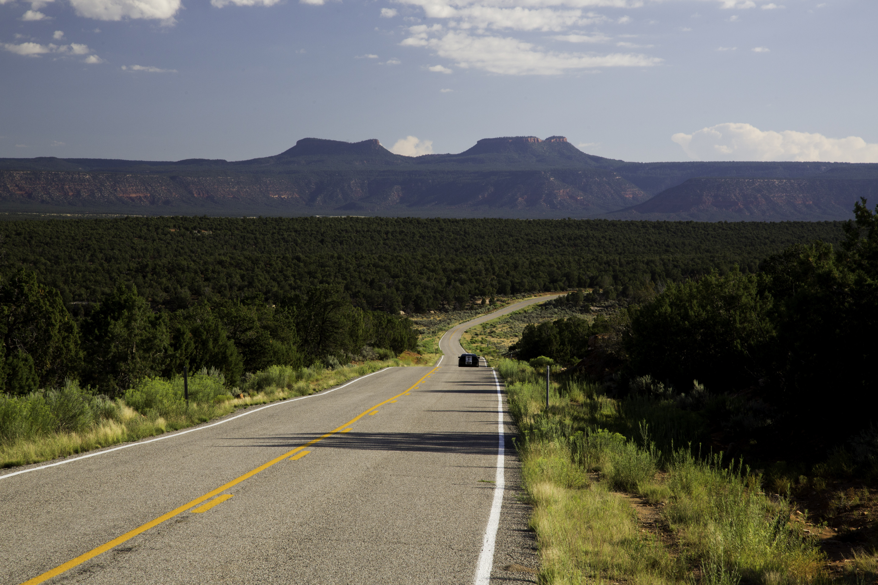
Current hopes for preservation of the Dirty Devil and the broader Colorado Plateau lie in designation of national monuments. Among these is the significant Grand Staircase-Escalante National Monument, designated under the Antiquities Act by President Bill Clinton in 1996, at 1.9 million acres. Proposals for other monuments include a Greater Grand Canyon Heritage National Monument. In the waning days of the Obama Administration, the President declined to designate a Grand Canyon monument. However, Obama heard the appeals of the five Native American nations of a Bears Ears Inter-Tribal Coalition for protection of the Bears Ears, two buttes that from a distance indeed look like a pair of ears just as a bear peeks over the horizon. Under the authority of the Antiquities Act of 1906, President Obama designated Bears Ears National Monument that carves out 1.35 million acres of public lands for protecting not only monumental scenery but also a cultural landscape of Pueblo cliff houses and some of the oldest rock art in the West. In addition, the designation affirms the value of Native American traditional knowledge by calling for first-of-its-kind management collaboration between the tribes and federal managers.

As the heat of summer dissipates and fall settles across the Colorado Plateau, I’ll head to Utah to explore the region encompassed by the new Bears Ears National Monument—hike its canyons, drink from its springs, sleep among the stars—before sinister forces descend upon this great wilderness, one of the last in North America. While this dry, high desert does not support faunal populations as large as some other regions of North America, the Plateau provides a vital corridor in the overall north-south migration of wildlife because of existing protected lands. However, even with limited potential for human settlement in this arid region, these lands remain threatened by resource extraction, off-road vehicle use, and overgrazing. More of these lands need the protection that will come with additional national monument and wilderness designations so that mule deer, pronghorn, coyote, cougar—the complete assemblage of animals—have free passage to move unimpeded through their domain.
And as part of the natural environment, humans also need these lands that offer solitude and silence and that challenge the spirit. As I learned along the Dirty Devil, the wilderness experience is a dialectic of taking and giving. Wilderness requires that you come out of yourself to confront rock and water and mud and wind and height and empty space, and then rewards you with newfound strength and confidence, and with confirmation you are worthy to be in this place, worthy to be who you have become in Red Rock Country.

© Russ Manning. All Rights Reserved.
An ebook copy of much longer text and complete references for the Colorado Plateau can be downloaded from amazon.com.