A portion of the Dirty Devil River Canyon has been designated a Wilderness Study Area by the Bureau of Land Management. In 1976, as part of the Federal Land Policy and Management Act (FLPMA), Congress directed the BLM to inventory their lands and identify roadless areas of 5,000 acres or more to determine the suitability of each for wilderness under the National Wilderness Preservation System established by the 1964 Wilderness Act. The FLPMA signaled a shift in federal policy, ending the era of land disposal by superseding all homesteading acts and focusing more on preservation of what remained.
The predictable reaction of the western conservative communities to the FLPMA was outrage that coalesced into the “Sagebrush Rebellion,” a de facto forum for local opposition. Various state and county governments passed legislation calling on the “return” of federal lands to the states. One of the latest efforts was Utah’s Transfer of Public Lands Act of 2012 calling for the transfer of all federal land within its boundaries to the state no later than 2015. Only problem was, those federal lands never belonged to the state. Federal ownership dates all the way back to the Mexican Cession, in which Mexico ceded what is now the southwestern U.S. to the federal government by treaty at the end of the Mexican-American War in 1848, including a payment to Mexico of $15 million. And indeed, the state gave up any claim to federal lands in the Utah Statehood Enabling Act of 1894, which states,
That the people inhabiting said proposed State do agree and declare that they forever disclaim all right and title to the unappropriated public lands lying within the boundaries thereof; and to all lands lying within said limits owned or held by any Indian or Indian tribes; and that until the title thereto shall have been extinguished by the United States, the same shall be and remain subject to the disposition of the United States…
So of course when Utah asked for “its land back,” the federal government just ignored the claim, and 2015 came and went without the handover of any public land.
Repeal of RS 2477 by the FLPMA was an additional irritation to the local opposition. This Revised Statute (Section 8 of the Mining Act of 1866) had only one statement, “The right of way for the construction of highways over public lands, not reserved for public uses, is hereby granted.” RS 2477 had been used since 1866 for the routing of roads across federal lands for ranching, hunting, mining, and connecting towns. While no roads could be constructed across public lands after 1976, the FLPMA stated that it did not terminate any valid existing right-of-way. So many in Utah claimed rights-of-way used prior to 1976 even when the route was just a stream bottom occasionally used by off-road vehicles and when many routes were hardly more than cow paths that do not go to any specific destination. Opposing RS 2477 claims continues to be a major campaign for conservation groups in Utah and elsewhere in the Southwest.
Among the myriad reasons for limiting roads into dry arid lands is the destruction of the cryptobiotic crust composed of moss, lichens, and cyanobacteria that covers the desert soil. The crust holds the sand in place, absorbing moisture and preventing water and wind erosion, and so enabling other plants to take hold. Tire tracks, horse and cow hooves, and admittedly hiking boots, crush the delicate crustal layer, which takes decades to grow back. Once the crust is disturbed, the sand begins to move, blown into dunes that cover undisturbed land, further killing the cryptobiotic crust.
The Southern Utah Wilderness Alliance has taken the lead on fighting Utah’s RS 2477 claims in the courts. Claims by the state total over 30,000 miles of dirt tracks crossing some private and state lands as well as federal lands, including national parks and monuments. An additional issue to address by SUWA and other wilderness advocates is the scattered parcels of land given to Utah to support public schools and managed by the state’s School and Institutional Trust Lands Administration. Many of these parcels occur in wilderness quality lands and may be sold off or developed at the whim of SITLA.
Following passage of the FLPMA, the BLM began its inventory, as directed by the legislation. An area determined to be suitable for wilderness protection became a Wilderness Study Area until such time as Congress decides if the area should be designated wilderness or released for other purposes. In the interim, the BLM manages the WSA as if it were wilderness in order to maintain the wilderness character until a decision is made.
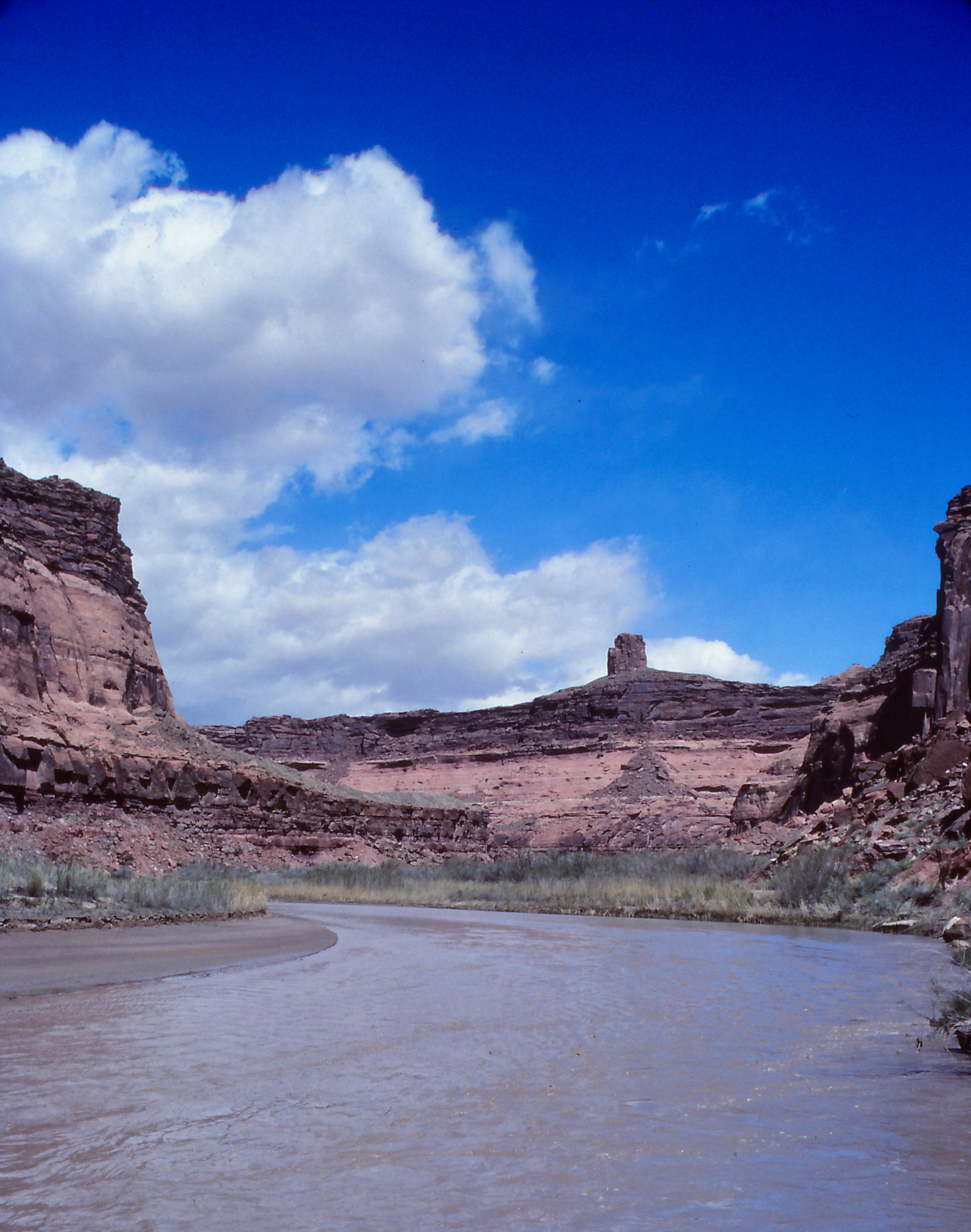
The designated Dirty Devil WSA contains 61,000 acres of BLM land, including some 30 miles of the river. The BLM states,
All of the WSA is in a natural condition and about 80 percent has outstanding opportunities for solitude and primitive recreation. … Sheer cliffs of the Navajo and Wingate formations, colorful sediments, sinuous tributary canyons, riparian vegetation along the Dirty Devil River and Beaver Wash Canyon and unbridled erosion reinforce the feeling of naturalness.
The Dirty Devil WSA is included in the BLM’s National Landscape Conservation System, created by the Secretary of the Interior in 2000 but then formally established by the Omnibus Public Land Management Act of 2009. This system brings together all the BLM National Conservation Lands that are designated for preservation and conservation—national monuments, national conservation areas, designated wilderness, WSAs, wild and scenic rivers, national scenic or historic trails, and any other area “designated by Congress to be administered for conservation purposes.”
The mission, the BLM states in its 15-Year Strategy, 2010 – 2025, “is to conserve, protect, and restore nationally significant landscapes and places that have outstanding cultural, ecological, and scientific values for the benefit of current and future generations.” All good words. Problem is, the sentiment only applies to the lands specifically designated in the various preservation systems—that’s 880 units across the country, amounting to 32 million acres, about 13% of the BLM’s 245 million surface acres. And even within these protected acres, the BLM says ominously, “Often, NLCS lands are working lands as well. The NLCS is not separate and apart from the mainstream of BLM-managed lands. NLCS land is connected to other efforts and activities – recreation, wildlife, botany and other like disciplines; and linked to minerals, energy, grazing and other uses.”
In Utah, the BLM manages 22.9 million acres with about 20% designated National Conservation Lands. That’s better than the national average, which is due in part to the work of conservation groups like SUWA that advocate for further wilderness designation. In response to the 1976 FLPMA mandate, the BLM designated 2.5 million acres in Utah as WSAs, later increased to 3.2 million acres in response to appeals from conservation groups. Still, those familiar with the region knew there are many more lands that qualify for protection. Surely there’s more Redrock Country that qualifies as “nationally significant landscapes”?
To answer that question, interested conservation groups in 1985 formed the Utah Wilderness Coalition, including SUWA. Volunteers set out to explore and map additional lands that might also qualify for WSA status. The result was a plan, set forth in Wilderness at the Edge, A Citizen Proposal to Protect Utah’s Canyons and Deserts, for 5.7 million acres eligible for wilderness designation.
In 1989, this Citizen Proposal was introduced into Congress by then-Utah Rep. Wayne Owens as America’s Red Rock Wilderness Act, which has since been introduced in every session of Congress. In the foreword to Wilderness at the Edge, Owens recounted how he had spoken with residents of southern Utah about the wilderness bill he had introduced and found “a great rift of opinion”; however,
I sometimes asked these residents if they would be willing to live in a place which was completely developed and exploited, without the quiet corners of natural beauty and solitude which make Utah so unique. The answer was invariably negative, so the real question becomes not whether to preserve significant portions of Utah’s wilderness, but, simply, how much.
In 1997, Illinois Senator Dick Durbin introduced a similar bill in the Senate for the first time.
Meanwhile, the UWC conducted additional fieldwork with the critical support of the Wild Utah Project, identifying another 3.4 million acres worthy of wilderness designation, bringing the total to 9.1 million acres. In 1999, the bill with expanded acreage was introduced in Congress and has since been introduced in both the U.S. House of Representatives and the U.S. Senate every session, increasing the number of cosponsors virtually every time. In the 115thCongress (2017-2018), 123 cosponsors signed on the House bill while 26 senators cosponsored the Senate version.
Compared to the total of 170,000 acres recommended by the BLM in the Dirty Devil WSA and the nearby Fiddler Butte and French Spring-Happy Canyon WSAs that surround the lower Dirty Devil River, America’s Red Rock Wilderness Act proposes a combined wilderness area of 334,000 acres—the Dirty Devil WSA (242,000 acres) and the Fiddler Butte WSA (92,000 acres). Part of the discrepancy between the two proposals is the BLM’s exclusion from their WSA of the Tar Sand Triangle, an area of about 200 square miles, including about 16 miles of the Dirty Devil River. The BLM admits that eventual designation of its defined Dirty Devil WSA as wilderness “would not preclude future in-situ recovery of available tar sand in the Tar Sand Triangle Special Tar Sand Area”—because the Tar Sand Area is simply excluded.
