Tennessee Trails Association/Cumberland Trails Conference/CTSSTSP
In November 1968, a small cadre of outdoors people met to discuss conservation issues in the state. Bob Brown, an avid hiker familiar with the Cumberland region, suggested a long-distance trail following the eastern edge of the Cumberland Plateau. A trail on the Plateau would make much of the Cumberland’s extraordinary landscape accessible to hikers while also connecting with trails in other states north and south to form a western alternative to the Appalachian Trail, now called the “Great Eastern Trail.” The idea of a trail in the Cumberlands was enthusiastically received at that first meeting.
Building on that vision, Mack Prichard, at the time State Naturalist with Tennessee’s Department of Environment and Conservation, brought together others who were interested in a trans-state trail, including Donald Todd, a regional conservationist, and Evan Means, at the time outdoors editor for a local newspaper. Means had already begun planning a trail in the Cumberlands, first as president of the Clinch and Powell River Valley Association in 1965 and later with Boy Scout Explorers and the Oak Ridge Conservation Club, and had led an inaugural hike to McLean Rock, a stone pillar in the Cumberland Mountains. Later Sam Powell, another of the state’s leading conservationists joined the effort. The group Mack brought together formed the Tennessee Trails Association (TTA), with Bob Brown as president and the Cumberland “Crest” Trail as their first project.
Off and on, the State of Tennessee embraced the idea of a Cumberland Trail, first designating the path one of the first trails in Tennessee’s State Scenic Trails System, created in 1971. The state assumed responsibility for constructing the northern half of the trail, while TTA took responsibility for the southern half. However, in 1991 lack of funds caused the state to withdraw its support. Bob Brown, perhaps more than any other, helped to keep the vision alive, maintaining his section above Grassy Cove on the South Cumberland and a section above Cove Lake State Park, while Sam Powell kept working on his Signal Mountain trail system near Chattanooga and Don Todd helped maintain trails in and around Frozen Head State Park and Natural Area, both by leading Boy Scout groups. The remainder of the route languished.
Then just as the vision began to fade, Rob Weber settled in the region, joining Tennessee Trails Association and becoming TTA President. Captivated by Bob’s vision of a long trail connecting state and national parks and natural areas on the Cumberland Plateau, Rob picked up the task, gathering volunteers to help revive the Cumberland Trail, along with TTA member Arleen (Scheller) Decker. The group formed the non-profit Cumberland Trails Conference in 1997 within TTA to focus on completing the trail.
With this framework in place, the volunteers sought federal and state grants and private funding to turn the vision into a reality. They succeeded in raising operating funds and established a new office and staff in Crossville with Rob as director, Arlene as resource manager helping to raise funds for the project, and Rob’s wife, Susan, as office manager.
In 1998, the state recognized the success of this grassroots effort by designating the Cumberland Trail as Tennessee’s first linear state park, a unique public/private partnership with the CTC taking the leadership in trail building and public outreach and the state taking care of closing acquisition agreements with landowners and managing the land. Bob Fulcher, long-time Regional Interpretive Specialist with the state, accepted the new job of state park ranger and later manager. Fulcher was especially instrumental in the state acquiring land and easements for the trail corridor; his success in that effort has been remarkable. Mark Stanfill has been a steady influence, serving as the CTC’s Trail Development & Maintenance Coordinator before leaving to join Tennessee State Parks as Trails Administrator and becoming part of the Cumberland Trail State Park staff where he oversees the state’s efforts at building the trail. The Cumberland Trail State Park includes more than 31,500 acres and intersects three National Park Service areas, three wildlife management areas, and six state natural areas, totaling over 330,000 acres of public lands.
In 2002, the state park was renamed for Justin P. Wilson, a former commissioner of the Tennessee Department of Environment and Conservation and later Deputy Governor, for his efforts in the early years to ensure state backing for the park as well as for his conservation work. However, if you find “Justin P. Wilson Cumberland Trail State Scenic Trail State Park” a bit cumbersome, everyone knows it also as “Cumberland Trail State Park.” The trail itself retains the name “Cumberland Trail,” just as Bob Brown wanted.
After five successful years, Weber left the CTC for other pursuits, later returning for a tour as Chair of the CTC Board. After a couple of interim directors, Tony Hook took over as CTC General Manager. Hook was responsible for completing many miles of trail during his tenure. CTC eventually separated from TTA, becoming an independent organization, and continues its work of building trail, with 210 miles completed at this writing. Frank Jamison serves as current Board Chair of the CTC.
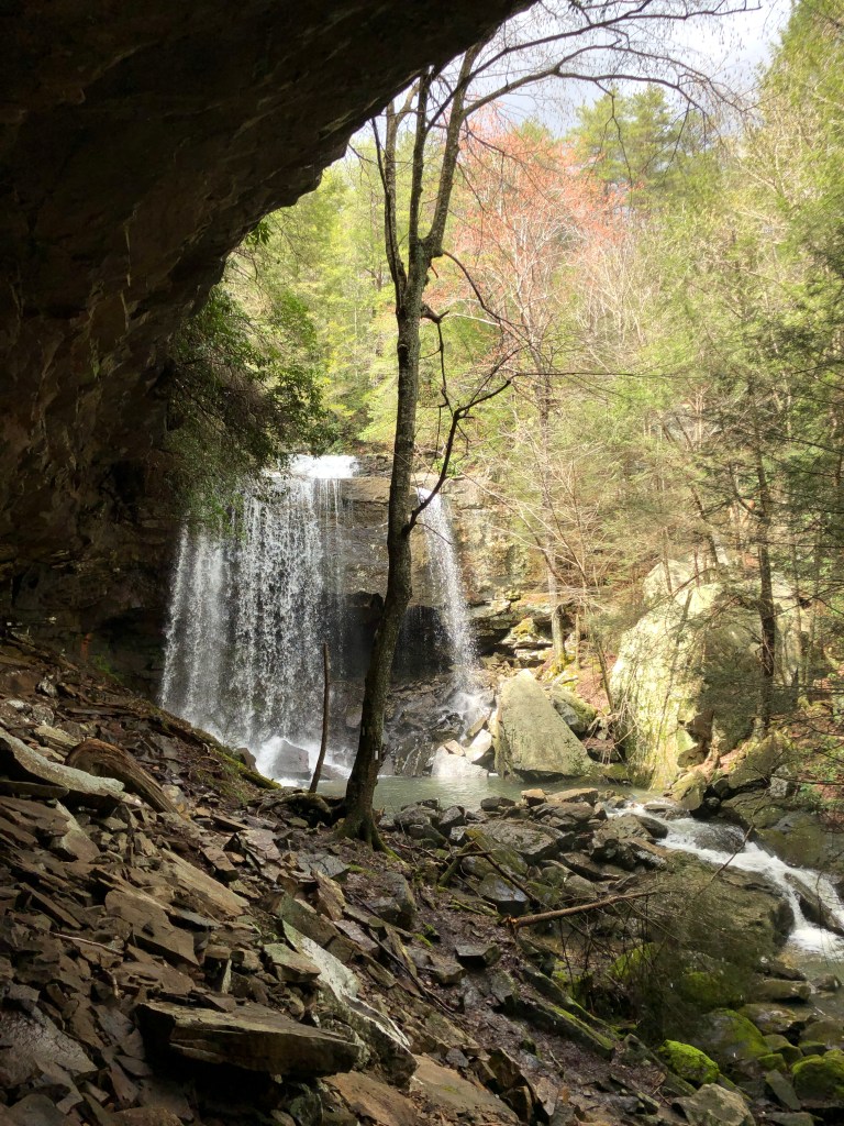
The Cumberland Trail continues to wend its way through the state as existing sections are linked into a 300-mile trans-state system, providing access to the outdoors of the Cumberland Plateau. But perhaps more importantly, this connected landscape also provides for movement of wildlife. As has happened elsewhere, parks and preserves acquired and connected for outdoor recreation have turned out to be equally important for preserving landscapes and permitting wildlife migration. When the CT is completed, the lands acquired for the trail will provide a nearly continuous wildlife corridor through the state southwest to northeast and beyond with connecting trails in other states.

The Nature Conservancy
The Nature Conservancy has played a primary role in preservation of the Cumberland Plateau landscape. TNC first became involved in conservation of the Plateau in 1970s, helping to acquire land for Savage Gulf State Natural Area, including the purchase of 4,138 acres in 1978 from the J. M. Huber Corporation. The State of Tennessee had designated the natural area in 1973 to protect the convergence of three canyons, locally called “gulfs,”—Big Creek, Savage, and Collins Gulfs—the protected area now totaling 15,590 acres. Recognized as a National Natural Landmark, this Class II Natural-Scientific State Natural Area includes 500 acres of old-growth, mixed-mesophytic forest, a complex association of hardwood species that include beech, tulip poplar, sugar maple, basswood, ash, and buckeye. Savage Gulf is protected under the Tennessee Natural Areas Preservation Act of 1971 as is 85 other natural areas throughout the state. Of these, 26 natural areas are on the Cumberland Plateau.
Acquisitions and receipt of donations of Plateau land by The Nature Conservancy also occurred during this time frame—Hubbard’s Cave, the first acreage for Colditz Cove State Natural Area, Tally Wilderness Preserve, Clifty Creek Preserve, Jim Creek Tract in Pickett State Forest, a portion of Bear Hollow Mountain Wildlife Management Area. Then in 2003, the Conservancy completed its first major project on the Plateau by helping acquire 75,000 acres from International Paper in the northern Cumberlands that became the Sundquist Wildlife Management Area, named for a former governor.
Change came rapidly as timber/paper companies operating in Tennessee joined the nationwide trend for such companies to divest themselves of landholdings. Bowater Incorporated, one of those with significant holdings on the Cumberland Plateau, announced in 2005 that it would sell off much of its land. The State of Tennessee stepped in, under Governor Phil Bredesen’s leadership, to take advantage of this unique opportunity and in 2006 purchased 12,500 acres from Bowater on the Plateau, including critical acreage connecting state-owned Bridgestone/Firestone Centennial Wilderness WMA, Bledsoe State Forest, and Fall Creek Falls State Park, which contains the tallest waterfall east of the Mississippi River; but also, Virgin Falls that Bowater had preserved as a “pocket wilderness,” destined to become a state natural area; and additional acreage for the Cumberland Trail. The pieces were coming together for a corridor.
The Tennessee Chapter of The Nature Conservancy thought much more could be accomplished in this once-in-a-lifetime opportunity. Scott Davis, at the time TNC’s State Director for Tennessee, reported at the time, “The Cumberland Plateau is one of the most biodiverse deciduous forest systems in the world.” Davis met with Governor Bredesen, to argue for taking advantage of the current divestitures before private interests acquired the land with development or resource extraction in mind. Conservation-minded and one of the founders of the Land Trust for Tennessee, Bredesen agreed. The Conservancy thru Davis and Associate Director Gina Hancock in 2007 partnered with the state and two timber investment firms (Conservation Forestry and Lyme Timber), with financial assistance from the Doris Duke Charitable Foundation and the Tucker Foundation, to secure 127,854 acres that would involve a combination of purchase, working forest agreements, and conservation easements. This included purchasing the timber on the existing 75,000-acre Sundquist WMA (the original acquisition was only for the land). The new project was called “Connecting the Cumberlands” because it linked existing public lands, including Frozen Head State Park & Natural Area to which some of the acreage was added. North of Frozen Head, the lands became the North Cumberland Wildlife Management Area that includes the Royal Blue, Sundquist, Brimstone, and New River units, administered by the Tennessee Wildlife Resources Agency.
In addition, The Nature Conservancy had long noted a missing piece on the Plateau also owned by Bridgestone/Firestone that is virtually surrounded by state-owned lands, including Virgin Falls State Natural Area and the donated Bridgestone/Firestone Centennial Wilderness WMA. Based on earlier success with the WMA, Bridgestone Americas, Inc. approached TNC to help with forestry management on this Chestnut Mountain property. Working together led Bridgestone to the decision that TNC could best manage the property and in 2018 donated the 5,700 acres that has since become the Bridgestone Nature Reserve at Chestnut Mountain. The reserve is now part of a 60,000-acre connected landscape of protected lands.
In 2007 when Connecting the Cumberlands was realized, everyone thought there would never again be such a huge success in preserving Cumberland Plateau lands. TNC Tennessee Director Davis at the time stated, “This is the single greatest conservation opportunity we are likely to see in our lifetimes.” However, twelve years later the Conservancy did it again.
In 2019, the TNC Tennessee Chapter under the leadership of Terry Cook, who had become State Director after Gina Hancock in 2016, created an investment fund to purchase 100,000 acres on the Cumberland Plateau in Tennessee and Kentucky and another 153,000 acres in Virginia as the Cumberland Forest Project, part of its overall plan to protect the wildlife corridor through the Appalachians, which TNC has designated one of four global priorities for conservation, along with Borneo, the Amazon, and Kenya. This new Cumberland Forest acreage is being managed as a working forest under sustainable practices and also as a carbon-offset project, both of which will generate income for the investment fund and provide recreational and economic opportunities.
The Tennessee-Kentucky portion of the Cumberland Forest Project is known as “Ataya.” There are various origins and meanings of the word; one is Arabic in origin, meaning “gift.” This ataya is especially important for wildlife migration because it links the 146,000-acre North Cumberland WMA with the 24,000-acre Cumberland Gap National Historical Park on the Tennessee-Kentucky-Virginia border. (In 2021, TNC and The Conservation Fund acquired an additional 850 acres that ensures this linkage.) To the south of North Cumberland is another contiguous 24,000 acres in Frozen Head State Park and Natural Area. Just to the south of Frozen Head is the Obed Wild and Scenic River. And connecting them all is the Cumberland Trail.
Tennessee Citizens for Wilderness Planning
William (Bill) and Liane (Lee) Russell personally guided me to my first view of the Obed River. This was just after the Obed and its tributaries were designated Wild and Scenic River in fall 1976. The Obed River had a long history of dam proposals, but none taken too seriously until the federal Tennessee Valley Authority, infamous for damming the valley’s rivers, began a new study for a dam on the Obed in 1965. Fortunately, the Russells had just canoed the Obed for the first time, passing through the magnificent sandstone gorge.
Bill and Lee were both internationally known research geneticists living in their small Oak Ridge community that had grown up surrounding federal research facilities during World War II. As well-known members of the conservation community, they were able to gather a number of others in 1966 to form Tennessee Citizens for Wilderness Planning, with preserving the Obed as their first project, along with a focus on stopping another road through Great Smoky Mountain National Park to the east; both efforts were successful. Dick Lorenz, another researcher in Oak Ridge, served as the first TCWP president.
Soon other organizations, including the Tennessee Scenic Rivers Association and the Tennessee Chapter of the Sierra Club, joined with TCWP to encourage preservation of the Obed River system rather than construction of yet another dam. The group urged the then-Bureau of Outdoor Recreation to conduct a study of the Obed. BOR took a few years but finally issued a recommendation that 100 river miles qualified for Wild and Scenic River designation under the National Wild and Scenic River System. To receive that designation took an act of Congress, which in the final vote included only 50 of the river’s miles in the Wild and Scenic status.
With that success, among others, TCWP had become a major force in conservation in the region. So with the Russells leading the way, TCWP became involved in saving another river gorge on the Plateau, the Big South Fork of the Cumberland River on the west side of the Cumberland Plateau. Again the spur to action was a dam proposal.
The Big South Fork flows north from Tennessee into Kentucky through a deep river gorge bounded by sandstone cliffs, similar topography to the Obed, before joining the Cumberland River. The Army Corps of Engineers had raised the idea several times of taking advantage of the deep gorge to construct the highest dam east of the Mississippi River at Devils Jump Rapids in the Kentucky portion of the river. To either side of the rapids, the sandstone walls stand 500 feet above the river, an ideal place for a dam that would impound the entire river gorge in Tennessee.
To put an end to dam proposals, TCWP began work to have the river gorge protected. This time, other conservation groups joined with TCWP to form the Big South Fork Coalition, with Lee Russell as coordinator. The group elicited the help of then-Senator Howard H. Baker, Jr., who in 1973 gained national recognition as the Vice Chairman of the Senate Watergate Committee investigation into the break-in of the Democratic National Committee headquarters at the Watergate office complex. Baker’s hometown was Huntsville, Tennessee, just a few miles from the New River tributary of the Big South Fork.
With TCWP’s encouragement, Baker suggested a national park for the Big South Fork instead of a dam. “I was further advised,” he said, “politely but pointedly, that I had absolutely no influence on the Interior Committee.” So he then proposed a bill coming out of the Public Works Committee for the Corps of Engineers to establish a park at the Big South Fork. The proposal was part of the 1972 Omnibus Rivers and Harbors Act, which failed to pass. The BSF Coalition took that setback as an opportunity and helped rewrite the bill so that the park would be turned over to the National Park Service for management after the Corps had created the park. The revised bill was reintroduced as part of the 1974 Water Resources Development Act, which passed. But rather than designating a national park, the bill called for the Big South Fork National River and Recreation Area, with virtual wilderness protection for the river corridor and with recreation area on the surrounding tableland. Together the two areas encompass 125,000 acres preserved on the Cumberland Plateau.
In the meantime, the Firestone Tire and Rubber Company had purchased land on the Plateau to create a corporate retreat, including much of the 18-mile Scotts Gulf, named for an early settler when Tennessee was still a territory. The area had been logged at one time and supported rural communities but has since grown up in a lush second-growth forest. Bridgestone acquired Firestone in 1988, but never used the property and so in the following years offered the property for sale. Seeking to preserve this dramatic landscape on the Plateau from development and resource extraction, the Scotts Gulf Committee formed, later “Friends of Scott’s Gulf,” a coalition of conservation groups that included TCWP. The Committee, including TCWP’s representative, Chuck Estes, worked tirelessly to encourage BF to donate the land to the state. As a result, then-Chairman and CEO Masatoshi Ono collaborated with at-the-time Governor Don Sundquist and the Conservation Fund to donate the property to the State of Tennessee. BF subsequently donated an additional 6,000 acres in 2000, and the area is now called the Bridgestone/Firestone Centennial Wilderness Wildlife Management Area. (In 2016, the Land Trust for Tennessee added an additional 2,600 acres.)
In the early 1990s, Pickett State Park and Forest on the Plateau was only about 9,900 acres. Then Stearns Coal & Lumber Company that owned many acres west of Pickett went into receivership and was looking to sell this property. Because the land is also characterized by sandstone gorges, pinnacles, natural arches, waterfalls, caves, and upland forest, conservationists, especially TCWP, began lobbying for public ownership. An initial scare resulted when a developer paid an option for the land. TCWP’s Jenny Freeman and Tennessee State Naturalist Bob Fulcher led the effort to save the land, which resulted in the Mellon Foundation purchasing 5,000 acres in 1994 and donating it to the state to be added to Pickett State Forest, along with another 600 acres purchased by the state.
Around the same time, The Nature Conservancy was focusing on the North Cumberlands. In 1999, TNC accepted a donation of 1,125 acres of the Burton Talley Tract, which was contiguous with the Pickett State Forest. TCWP members, Frank Hensley especially, were monitoring these additional acquisitions and are credited with much that followed. In 2000, the Tennessee Forestry Division purchased the 1,180-acre Cunningham Tract adjacent to Pickett. The Nature Conservancy purchased the 1,541-acre Jim Creek Tract the following year. Also in 2001, TCWP members elicited TNC to purchase another 480 acres west of Pickett on the Kentucky border; the land is known as the Dobbs Creek Preserve. The Kentucky TNC later purchased 710 acres bordering both the Dobbs Creek Preserve and the Cunningham Tract. And finally in 2005, TNC purchased the 3,720-acre Pogue Creek Tract that lay between Pickett and the Jim Creek Tract, completing a 25,000-acre “Greater” Pickett that is contiguous with Daniel Boone National Forest’s 708,000 acres to the north and the Big South Fork National River and Recreation Area to the east.
In 2006, the State of Tennessee purchased 3,000 acres of TNC lands to create the Pogue Creek Canyon Class II Natural-Scientific State Natural Area, the highest ranking for Tennessee natural areas because of the significant geological and natural features.
Tennessee Citizens for Wilderness Planning continues its strong commitment to “Taking Care of Wild Places.” While the Russells continue to inspire the organization, they are missed. Bill passed away in 2003 at 92 years old. Lee continued to edit the well-respected TCWP Newsletter, for a total of more than 50 years, that thoroughly outlines conservation issues across the state and the nation until her death at the age of 95 in 2019.