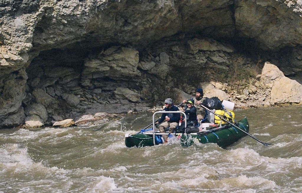
“No way…” I look down a 30-foot drop to the Blackfoot River. Here at Roundup, an access just off Hwy 200, at least there’s the intent of getting boats to the water—two railings point down the slope in a makeshift slide for canoes and maybe driftboats. But the slide is too narrow to handle Jason’s catamaran, two huge green tubes joined by an aluminum frame. After moving to Montana, my stepson became a modern-day mountain man, and with modern-day mountain men come the requisite modern-day mountain-man toys; thus, the catamaran.

On this beginning day of fall, Jason wants to show his mom, Sondra, and me a stretch of the Blackfoot River. The Blackfoot Valley that the river forms is surrounded by a vast ecosystem that anchors the southern end of the Yellowstone to Yukon Corridor stretching from the Yellowstone country of Wyoming and Montana north through Alberta and British Columbia and into the Yukon Territory of Canada. The Y2Y, as the corridor has come to be called, protects the wild pathways of the Northern Rocky Mountains. Protected migration routes of elk, wolf, and grizzly, crucial to an ecosystem, likewise protect the movement of smaller species—mule deer, pronghorn, lynx, wolverine, beaver, pheasant, prairie falcon—an ebb and flow through the Rockies and its foothills and valleys.
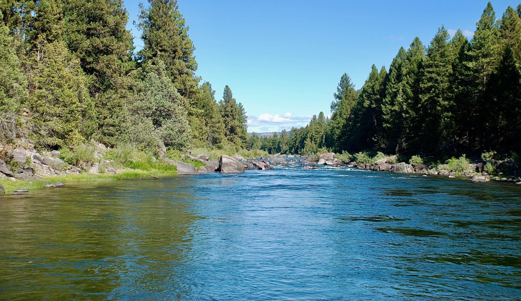
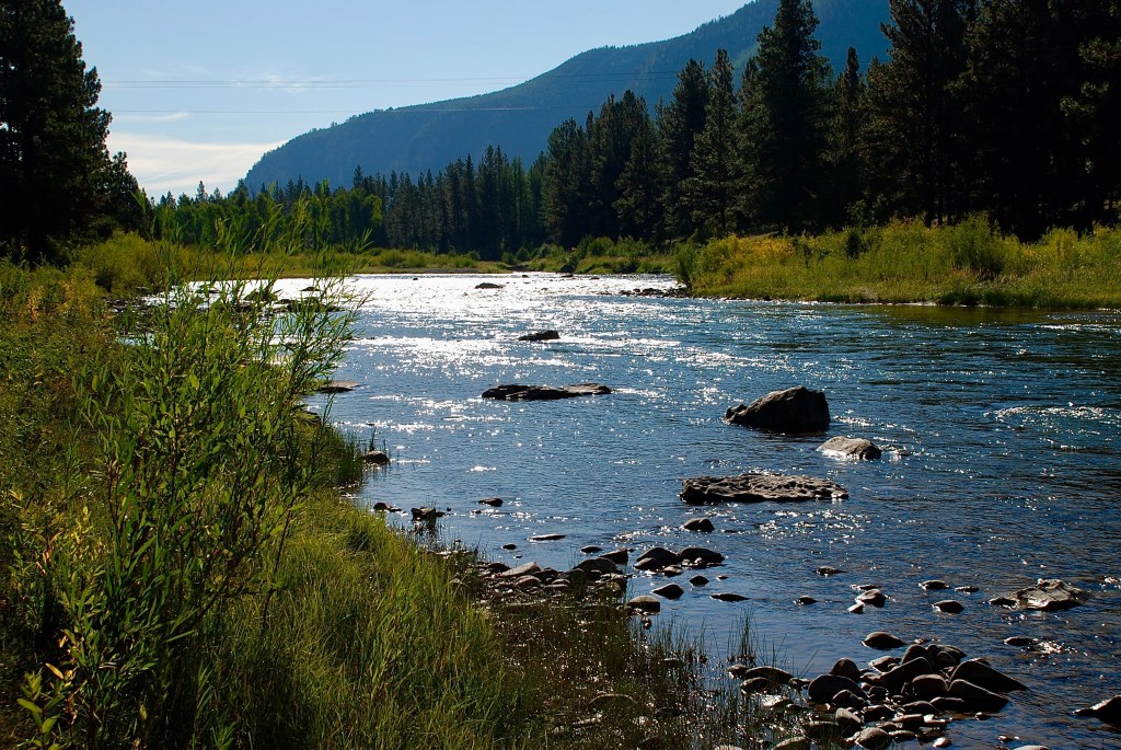
The Blackfoot River flows through a portion of the Y2Y’s Crown of the Continent ecosystem in western Montana. The 132-mile Blackfoot heads at the Continental Divide south of Glacier National Park and flows westward to join the Clark Fork just east of Missoula, part of the watershed of the Columbia River that delivers the Blackfoot waters to the Pacific. The river’s sometimes called “Big Blackfoot,” as Norman Maclean refers to it in his novella, A River Runs Through It, to distinguish it from the Little Blackfoot, another tributary of the Clark Fork to the south. Maclean in his semi-autobiographical novella extols not only fly fishing, but the river itself:
Like many fly fishermen in western Montana where the summer days are almost Arctic in length, I often do not start fishing until the cool of the evening.
Then in the Arctic half-light of the canyon, all existence fades to a being with my soul and memories and the sounds of the Big Blackfoot River and a four-count rhythm and the hope that a fish will rise. Eventually, all things merge into one, and a river runs through it.
Returning from the Pacific in 1806, Meriwether Lewis and William Clark decided to split up to see more of the western country that President Thomas Jefferson had sent the Corps of Discovery to explore. Lewis would head northeast to the Marias River, while Clark would head southeast to strike the Yellowstone River.
On July 3rd, Lewis wrote, in the typical bad spelling of the time, “I took leave of my worthy friend and companion Capt. Clark and the party that accompanyed him.” Lewis had with him nine expedition men, seventeen horses, Lewis’s dog Seaman, and five Nez Percé guides, or Nimi’ipuu as they called themselves. The Nez Percé soon left the group, not wanting to encounter belligerent tribes to the east. Apparently it was a sad separation; the expedition had been with the Nez Percé for two months. “…these affectionate people our guides,” Lewis wrote, “betrayed every emmotion of unfeigned regret at seperating from us…”
Passing through the present site of Missoula, Lewis and his party hit the Blackfoot River that the Nez Percé called Cokahlarishkit, which loosely translates to “river of the road to buffalo,” referring to the way east to the Great Plains with its great herds ranging in the tens of thousands of American “buffalo” (Bison bison). Lewis followed Cokahlahishkit upstream, which eventually came to be named for the Blackfeet Nation, the most powerful Native American tribe on the upper Missouri, called “blackfoot” or “blackfeet” because of their black moccasins. He described the river in his journal:
…wide deep and rapid. The banks bold not very high but never overflow. … beds composed of sand and gravel; the East fork [Lewis apparently referring to the main Blackfoot channel, with the North Blackfoot tributary coming in from the north] possesses a large portion of the former. neither of those streams are navigable in consequence of the rapids and shoals which obstruct their currents.

If we had read Lewis’s description before our river trip, we might have worried about making it down the Blackfoot. Even without Lewis’s warning, though, I point at the river map to squiggly lines in several places marking “rapids and shoals.”
“The cat won’t have any problem,” Jason assures us. The green tubes, each as big around as a garbage can, have little draft. And since the frame spans a gap between the tubes, the catamaran can even pass over a boulder.
“But how do we get the cat down to the river?” I ask, looking at the canoe slide that definitely will not work for us.
Jason has walked away, scouting the shore. “Here.”
We gather with him at the top of the bluff and look down a jagged slope with jutting rocks and roots. “Down that?” I exclaim more than ask. “Aren’t you afraid of puncturing your tubes?”
“No, it should to be able to handle that.” He grins, “Besides, it’s still under warranty.”
So Jason backs his truck with the trailer carrying the catamaran to the precarious pitch down to the river, where we get it unloaded. Before tipping it over the edge, he gets on the downhill side. “I’ll pretty much do this. You guys just keep it from running over me on the way down.” We grab on the back.
In fact there’s little for us to do as he jerks the thing downhill; it won’t slide for all the rocks and stumps. The cat hangs up on one stump, and we have to jockey it over to one side to move it on down to the water where, once it floats, the boat lazily pulls with the current.

The whole process has only taken a few minutes. “Well, that was a lot easier than it looked,” I comment. Sondra, and I find places to sit in the front, and finally, Willie, Jason’s dog, a German shorthaired pointer jumps right in, knowing his place.
(one of 10 most endangered rivers in 2018 by American Rivers)
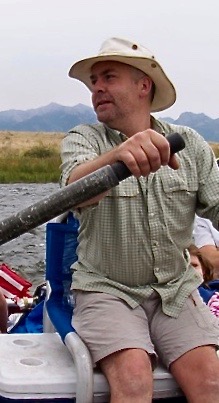
Jason pushes us off, jumping on, taking his seat, and grabbing the oars to pull us out into the current that carries us downriver.
Boulders rise from the water, the impediments that made Lewis record the river as unnavigable. But two hundred years ago, boats were clumsy and heavy. Our modern-day catamaran is agile, gliding through rock jams, sidestepping deftly in response to Jason’s oars.
“Look at that,” Sondra points. We’re not sure what it is at first, red against rock. But as we draw closer we see it’s a canoe wrapped around a boulder standing a few feet out of the water.

“Those folks had to walk home,” I comment. Maybe Lewis was right after all.
On the day Meriwether Lewis passed along the Blackfoot, he camped near Ovando at the junction of a small creek he named “Seaman” after his dog. But now the small tributary is called “Monture” for George Monture, killed near here in 1877 by unidentified Indians, apparently in an argument over whiskey, perhaps because he would not trade with them illegally.
Noticing some peculiar mounds in the Blackfoot Valley, Lewis called the area “prairie of the knobs.” Geologists have since explained that these knobs of earth and rock were pushed up by advancing glaciers and then left as the ice retreated at the end of the last ice age 10,000 – 12,000 years ago. The knobs are still quite prominent in the valley. In Ovando, several knobs stand on the plain out beyond the town.

On the south side of the Ovando town square stands the Blackfoot Angler fly shop, and next door the Stray Bullet cafe, one of the former saloons. Time was, you could get a drink about anywhere in town; now the cafe serves up espresso and lunch. The cafe got its name from a stray bullet that was discovered lodged in one of the 100-year-old hand-hewn logs when wallpaper was stripped away in a renovation years ago. The bullet is encased in a small empty picture frame, about ten feet up on the right-hand wall.

On the other side of the Stray Bullet rests the office of the Blackfoot Challenge, an organization of landowners, federal and state representatives, business owners, and conservation groups that had its beginnings in the 1970s and formally came together in early 1993 as a community-based nonprofit. Their purpose: to maintain the traditional lifestyle epitomized by Ovando and the surrounding ranches while also preserving the Blackfoot Valley, “ridge-to-ridge,” little changed since the time Meriwether Lewis described it:
… thus far a plain or untimbered country bordered the river which near the junction of these streams spread into a handsome level plain of no great extent; the hills were covered with long leafed pine and fir.
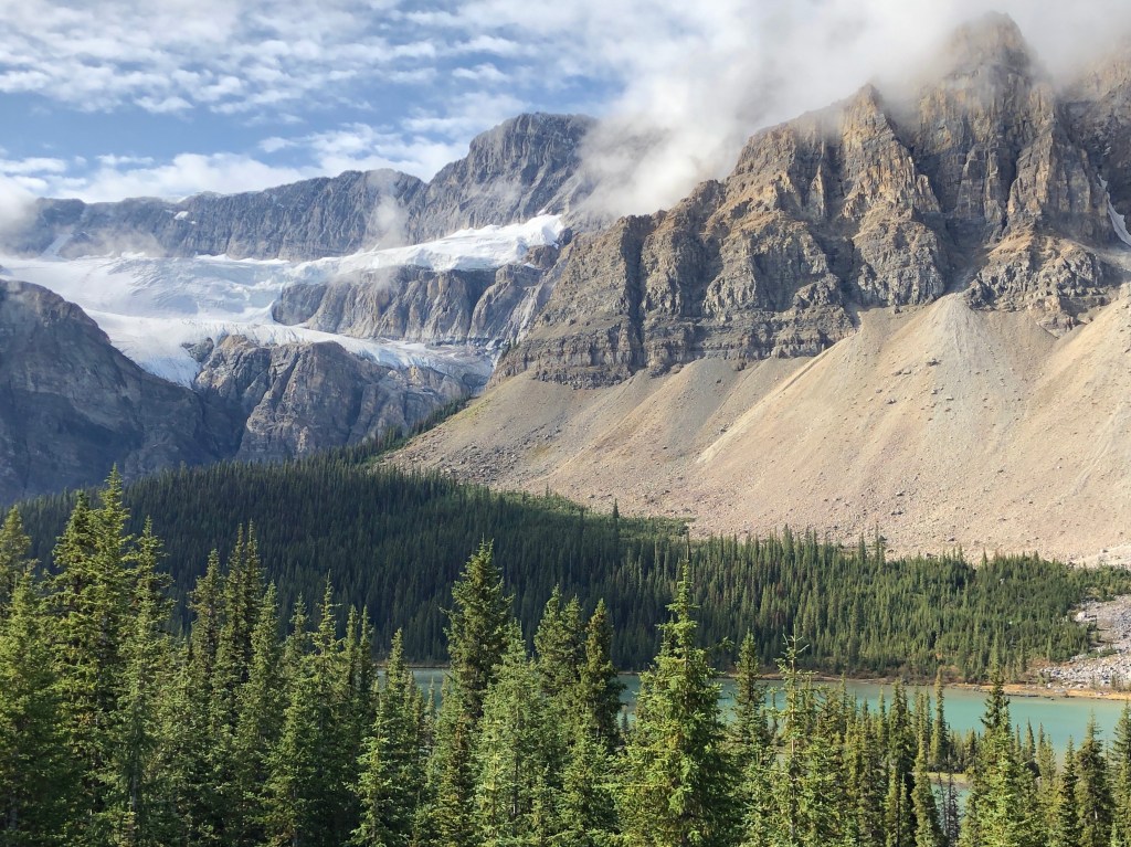
The Blackfoot watershed embraces 1.5 million acres of mountain slopes that settle into prairie grasslands and sagebrush plain sprinkled with coniferous woodlands, wetlands, and streams. With the adjacent Bob Marshall Wilderness complex, which includes the Bob Marshall, named for the famed conservationist, Great Bear, and Scapegoat wilderness areas within four national forests, and with Glacier National Park on the north, this is one of the largest regions mostly free of roads in the lower 48.
The Blackfoot River had suffered some environmental impacts and was headed to becoming another polluted river with runoff from unreclaimed mines, pastures, and bare stream banks. Restoring water quality became a high priority along with preserving the land and its culture. The remarkable success of the Blackfoot Challenge in accomplishing its goals makes it a model for other such efforts across the West.

For the Blackfoot Challenge to be successful, government has had to be engaged. In addition to private landowners, nearly ten government agencies and other groups own and manage land in the valley. Only about 25% is privately owned. Obviously, private landowners can’t control what happens to the valley on their own; all stakeholders have to be involved. To get consensus among so many stakeholders is understandably difficult. So the Challenge views the effort as a process with one of the principles to
Practice the 80/20 rule. When you think of barbed wire, it’s the pointy part that comes to mind, right? When in reality, the majority of barbed wire is smooth. We believe it’s the same when talking about values. If we focus on what we have in common, the values we share, we can get stuff done without getting hung up on the barbs.
That’s certainly the key to success: focus on the common values held by all to preserve the land and a way of life, even when points of view put them on opposite sides of a specific issue.
Among the conservation groups supporting the Blackfoot Challenge, The Nature Conservancy stepped in to purchase lands from the Plum Creek Foundation, affiliated with the Plum Creek Timber Company. TNC and the Blackfoot Challenge took advantage of the opportunity to protect the Blackfoot watershed through the divestiture of Plum Creek timberlands.
The Blackfoot Valley contains something like 600 species of vascular plants and 21 species of wildlife, including Canada lynx, wolverine, gray wolf, grizzly bear, bald eagle, elk, mule deer, moose, sharp-tailed grouse, bull trout, trumpeter swan, and a variety of other waterfowl.
“So what is that?” I see a water bird gliding along the shore at a distance from our boat.

“Merganser,” Jason says, and as we approach I see the rust-red crest of the female common merganser; the male, nowhere in sight, has a black head. A large diving duck, sometimes called “sawbill” for its serrated bill, Mergus merganser tops the riverine food chain, feeding on frogs and aquatic insects in addition to its main diet of fish.
A small gray bird skips from rock to rock, doing knee bends and then bobbing its head into the river, reminiscent of those toy birds a few years back dipping their plastic beaks into water that is soaked up to create a counterweight and causing them to lift their heads long enough for the water to run out before dipping once more. “Some kind of dipper,” I guess, which I later confirm as American dipper. One of the few aquatic birds considered a songbird, Cinclus mexicanus has a twittering, metallic song. In his book, The Mountains of California, John Muir wrote of the water ouzel, another name for the dipper:
He is a singularly joyous and lovable little fellow, about the size of a robin, clad in a plain waterproof suit of bluish gray, with a tinge of chocolate on the head and shoulders. …Among all the mountain birds, none has cheered me so much in my lonely wanderings—none so unfailingly. For both in winter and summer he sings, sweetly, cheerily, independent alike of sunshine and of love, requiring no other inspiration than the stream on which he dwells.
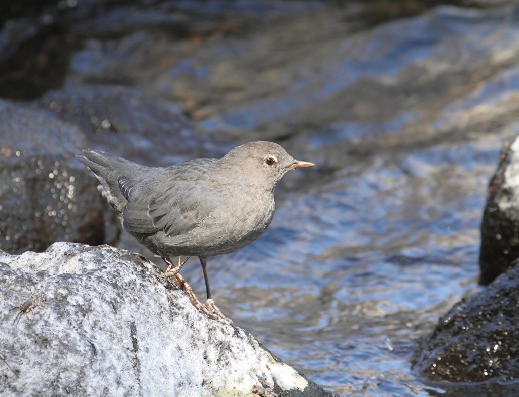
The dipper feeds on aquatic insects, snails, and small fish while wading or diving in the Blackfoot waters, even walking on the river bottom. A nictitating membrane, an extra eyelid, protects the eye while allowing the ouzel to see underwater. And it must see far, because as we gaze into the Blackfoot’s waters from the catamaran, we’re struck by the clarity of the water.
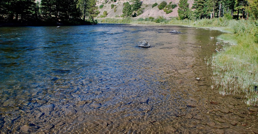
The river’s rapids are interspersed with flat pools where we can see clear to the bottom as the catamaran skims along, a scattering of multicolored stone amid the sand and gravel shoals that Meriwether Lewis noted.
The successful effort at preservation in the Blackfoot Valley is but a microcosm of the equally successful but larger cooperative effort to reestablish and preserve the Yellowstone to Yukon Corridor. While the Blackfoot Valley, especially the conservation area around Ovando Mountain and surrounding wilderness areas, support local migrations, these are but small segments of larger migration routes. As Barry Lopez says in his eloquent evocation of the northern latitudes, Artic Dreams, “… animals are always testing the landscape. They are always setting off in response to hints and admonitions not evident to us.”
Y2Y’s Central Canadian Rocky Mountains
The vision of reestablishing wildlife corridors emerged from the work of conservation biologists in the 1960s – ’80s who gathered evidence that insularized parks are not effective in maintaining wildlife populations, and who thought that corridors linking these parks might be the answer. In the early 1990s, efforts to actually re-create or preserve existing corridors began to take shape. For the Northern Rocky Mountain region, a nonprofit Yellowstone to Yukon Conservation Initiative was formed to take this science-based solution and turn it into on-the-ground implementation. Today, the Initiative has offices in Bozeman, Montana, and Canmore, Alberta and more than 450 partner organizations.

Greater Yellowstone Ecosystem
Credited with the notion of a Y2Y Corridor, Harvey Locke, a Canadian lawyer and conservationist, relates on the Initiative’s website,
In the summer of 1993 a 14-day walking traverse of the Willmore Wilderness Park north of Jasper National Park, followed immediately by a horse trip in the wild Northern Rockies of British Columbia made it clear to me that there is one gigantic linear ecosystem that extends from Yellowstone to the Yukon.
By a campfire above Keily Creek in the heart of what is now called the Muskwa–Kechika, I pulled out a pen and began writing on a topographic map. I wrote the words “Yellowstone to Yukon” for the first time with the conviction that this was the right scale at which to think and act.
While Locke was the visionary, Pluie was the inspiration. Like Alice the Moose at the Algonquin to Adirondacks Corridor and the jaguar throughout the Path of the Panther, Pluie the wolf demonstrated the interconnectedness of the Y2Y and the need wildlife have for expansive landscape.
In June 1991, a female gray wolf was radio-collared in the Kananaskis Country of Alberta, just southeast of Banff National Park. It was a rainy day, so the researchers named her Pluie, French for “rain.” After being released, Pluie headed east and then south, crossing into Montana. Turning west, she passed the foot of Glacier National Park, crossed into Idaho’s panhandle, and set foot in the state of Washington before turning back east. Recrossing the panhandle into Montana and then turning north, Pluie eventually returned to Banff National Park. Wandering an area of more than 40,000 square miles and crossing perhaps 30 political jurisdictions, Pluie showed that to be effective wildlife conservation must be on a scale beyond state, province, or even national borders.
The Northern Rockies has proven to be a fortunate choice for a creating an international mega-corridor—the mountains host numerous national and provincial parks and forests plus First Nation lands so that steppingstones along the corridor already exist. And in this region less populated than the eastern parts of the U.S. and Canada, wildlife have not yet lost their drive to migrate. In its efforts to open the way for free-roaming wildlife, the Y2Y Conservation Initiative outlined the proposed 2,100-mile-long corridor, dividing the designated 502,000 square miles along the route into eleven priority areas (see sidebar).

Y2Y’s Crown of the Continent
Fascinated by the Y2Y vision, German photographer, Florian Schulz, documented Yellowstone to Yukon in his photographic book, Freedom to Roam. Schulz anticipates our question: “Why would a photographer from Germany spend ten years photographing the Rocky Mountains of North America?”
The answer is that we have nothing in Europe that matches the sheer size and scope of the Y2Y area, with its wide-open landscapes and incredible array of wildlife. Most significantly, we don’t have true wilderness. We have lost our wildlands. Large wild animals have long since perished. In North America, especially in the vast expanse of the Rocky Mountains, true wilderness still exists.
With its longer human settlement, Europe no longer has natural landscapes with migrating species. But like Africa’s Serengeti/Masai Mara, North America’s Rocky Mountains still have land migrations as large, if less exotic only because the animals more familiar to us.
The Yukon region alone at the northern end of the Y2Y contains perhaps the largest intact predator-prey system in North America, with wolves, wolverines, black bears, lynx, elk, mountain goat, Dall sheep, moose, red fox, caribou, wood bison, and an especially high concentration of grizzlies. Many species still wander across their traditional ranges, and some reach their southern or northern range in this region. The Porcupine Caribou Herd, with summer calving grounds in Alaska’s Arctic National Wildlife Refuge, heads southeast come winter, ranging into the northern reaches of the Y2Y.
As narrated in Being Caribou, Karsten Heuer with filmmaker, Leanne Allison, followed the migrating Porcupine Herd on a remarkable 1,000-mile journey. Heuer tells of an encounter with caribou that inspired the undertaking:
Caribou cows and their newborn claves dotted every hillside and skyline, pouring over dark rocky slopes and lingering snowdrifts in waves and streams that spread like shadows toward the Firth River. …the silence that came behind them was almost unbearable.

So should the Y2Y arbitrarily stop at the corridor’s northern reaches of the Greater Mackenzie Mountains since animal populations respect no imaginary boundaries?
Heuer had already completed an epic 2,200-mile journey along the Y2Y Corridor, recounted in Walking the Big Wild; Allison joined in the midst of the trip. Their journeys demonstrated the corridor actually reaches all the way to the Arctic and into Alaska—if you allow the wildlife to determine the extent of the corridor. In Freedom to Roam, Heuer says,
Like the grizzly bears, the wolverines, and every other wide-ranging mammal we’d followed, the caribou would tell us what our tired muscles and achy bones already knew. There are no boundaries to the Y2Y vision, no borders beyond which wildlife do or don’t go.
The Y2Y Conservation Initiative would not disagree that the Y2Y vision ranges beyond the currently defined boundaries and priority areas of the Y2Y Corridor. Y2Y initiative co-founders Harvey Locke and Gary Tabor state in Freedom to Roam,
Y2Y is a beacon of what is possible for the protection of ecosystems that encompass far more than a few designated parks and forests. … Yellowstone to Yukon is an idea whose time has come, and a testament to the power of a vision when people apply knowledge, initiative and their hearts to creating a better future.
The day is well along as we continue down Montana’s Blackfoot River, so we watch for the next takeout. Meriwether Lewis described the river’s cliffs “bold not very high.” Still, they cast their shadows across the water, cooling the air as we dig out jackets we had brought along and pull them on. At the takeout, Jason guides the boat to shore where we unload and tie up.
While we wait for a boat of fishermen to arrive who will give us a ride back to our putin to retrieve the truck, Jason gets out his fly rod. Wading into the shallows, he casts, not caring whether he gets a bite or not, just enjoying the calm of the waning day as Sondra and I sit on the bank watching him “…in the Arctic half-light of the canyon, … Eventually, all things merge into one, and a river runs through it.”
Once we’re back with the truck, we reload gear and haul the boat out of the water onto the trailer. After which we head back east toward Helena and Bozeman, we in our car and Jason in the truck with boat in tow. Crossing MacDonald Pass on US12, night has come and a full moon floats above the horizon, flooding the widening landscape of the Y2Y with an aurora of pale pink light.

© Russ Manning. All Rights Reserved.
An ebook of much longer text and complete references for Yellowstone to Yukon: The Blackfoot can be downloaded on amazon.

This 2nd edition published in 2025 updates the current status for wildlife in the region, especially grizzlies, bison, and wolves, and the latest accomplishments in establishing connectivity in the Y2Y Corridor. A new Introduction summarizes the scientific research that identified the need for wildlife corridors to preserve biodiversity in North America.

Wow! I feel an inner calmness and serenity after reading this passage from Russ Manning’s “Yellowstone to Yukon: The Blackfoot”. I am an armchair explorer who enjoys getting lost in the telling of others’ adventures. I must read the ebook!
LikeLike